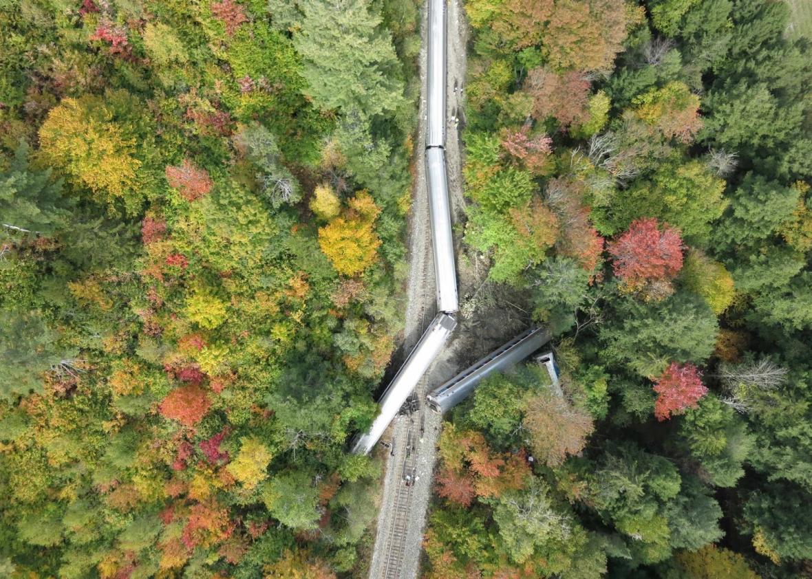
Photo courtesy of the Spatial Analysis Lab at the University of Vermont
When an Amtrak train went off its tracks in the forests outside of Northfield, Vermont, Oct. 5, state authorities needed pictures of the site to determine how best to respond and to document the damage for later investigations. So they decided to call in the drones, operated by the Spatial Analysis Lab at the University of Vermont. Within two hours, the university’s drone disaster response teams were flying their fixed-wing eBee unmanned aerial vehicle, or UAV, over the crash site.
Within an hour of arriving on the scene, the team’s drone shot 280 images of the derailment, with each high-resolution image linked to a precise location on the ground. By the end of the day, the drone team had processed the images into a seamless orthophotomosiac, a photographic “map” of the crash site that would come in handy for investigators.
As the Vermonter crash response shows, drones have in recent years become an easy and inexpensive way to collect invaluable images of accident and disaster sites: faster than a satellite and cheaper than a manned helicopter or airplane. Disaster response drones have been used in Nepal, Haiti, and Vanuatu and are increasingly finding their way into the toolkits of disaster response teams in the U.S.—including in Vermont, a surprisingly ideal testing ground for disaster drones.
Jarlath O’Neill-Dunne is the director of the Spatial Analysis Lab at the University of Vermont and served as mission commander during the response to the derailed train. A trained forester with military experience, O’Neill-Dunne first became interested in using drones for responding to and documenting disasters after Hurricane Irene swept through Vermont in 2011, destroying homes, roads, and bridges.
“It caused havoc for us,” says O’Neill-Dunne of the hurricane year. “We got a foot of rain in about an hour. … We had the ability to use satellites, but we found it wasn’t really that effective.” Clouds regularly covered relevant areas, and getting the right imagery on time to the right people proved to be a huge hassle. O’Neill-Dunne applied for a Department of Transportation grant, intending to study how drone imagery could help document destruction and get transportation going again after a natural disaster. Since, the lab has acquired two eBee drones from the French Sensefly company: black and yellow foam flying wings that weigh about 1.5 pounds and are equipped with sophisticated automatic flight-planning technology. As they’ve gained experience with flying their drones and using the data, the lab has developed a swift but formal protocol for deploying to the scene—with checklists and an established mission structure intended to keep the response organized and safe.
Unlike many other drone pioneers in the U.S., O’Neill-Dunne’s SAL lab has an easy relationship with state and federal regulators: The drone pilots work closely with state airspace authorities, and Vermont’s limited land area and small population have proved a good testing ground for drone disaster response tactics. The University of Vermont also holds a Section 333 exemption from the Federal Aviation Administration, allowing it to legally use the UAVs under controlled conditions out of the state.
Even before the derailment, the drones proved their utility for small-town disasters, after destructive rainstorms hit central Vermont on July 19. In the riverside town of Plainfield, the team used the eBee to carry out a rapid assessment of the damage to homes and roads and studied the aerial imagery to figure out how much wood and other debris was clogging local streams, potentially making bridges impassable.
In Barre, the team used the aerial imagery to document flooding destruction and to trace the spread of sediment in homes and on roads in exact detail—specific data that would make it easier for homeowners to get disaster relief assistance from FEMA. “Drone imagery didn’t help with the response—everyone knew whose house had flooded. But if you apply for disaster assistance, now you have survey-grade data,” says O’Neill-Dunne.
Will drones soon become a pedestrian part of disaster response, as expected as fire trucks and ambulances? While it’s quite possible, plenty of challenges still stand in the way of drone-disaster response spreading to the rest of the country. For one thing, there’s public concern over privacy and how camera-equipped drones might violate it. O’Neill-Dunne is sensitive to these worries but points out that the nadir (straight above) drone imagery he shoots isn’t much good for spying, considering that it’s hard to positively identify someone by looking at the top of their head. “It’s not a surveillance tool, it’s a mapping tool. We’re trying to use it in that realm, with the hope of alleviating the concerns of a lot of people,” he says.
Regulatory issues remain the biggest hurdle for disaster drones: The technology remains in a tricky legal gray area in the U.S., with final federal regulations set to come out sometime next year. That’s worrisome for drone disaster responders like O’Neill-Dunne. “If we had legislation banning drones flying over private property, especially in midmorning when people aren’t home and can’t give permission, we couldn’t do it,” he says. “We do need to consider privacy concerns, but is there a difference between someone shooting an image of your house from their car or a drone or a satellite?”
Ultimately, O’Neill-Dunne believes that the sheer usefulness of drone technology will overcome public trepidation, especially when it comes to small towns that lack the resources needed to send out helicopters or purchase pricy satellite information when disaster strikes. Instead of relying on bigger state or federal agencies, small American towns—already proud of their self-reliance—may soon be able to use drones to deal with both natural and man-made disasters.
http://www.slate.com/blogs/future_tense/2015/10/09/how_vermont_used_drones_after_an_amtrak_derailment.html
