You Can Now Buy Special Ammo Just for Shooting Down Drones

You Can Now Buy Special Ammo Just for Shooting Down Drones1

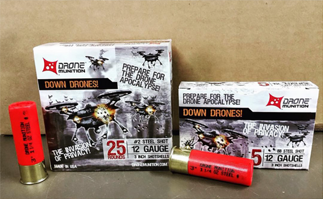
Have you ever wanted to shoot a drone out of the sky but just didn’t have the right kind of bullets? You’re in luck, you violent-minded human, you. Snake River Shooting Products just started shipping its Drone Munition. “PREPARE FOR THE DRONE APOCALYPSE!”

The Idaho-based company says that the shotgun shells come with “high quality load that will effectively disable a drone encroaching your property’s airspace.” You should realize that shooting down a stranger’s drone might come with some legal consequences. That is, unless you do it in self defense. It’s unclear if what self defense will look like if the drone apocalypse does descend upon us in the near future. But maybe for new let’s not shoot robots out of the sky—unless you have a drone hunting license, of course.

http://gizmodo.com/some-people-in-idaho-made-special-ammunition-to-shoot-d-1724875105


Sort of like:


Drone business picking speed with a startup in Modesto

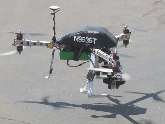
N9536T

Bianca Graulau,

The commercial drone industry is taking off, and Drone for Hire founder Thomas Davis wants to use the technology to help business owners, like farmers, work more efficiently.

“It allows farmers to survey large area of land in a very small amount of time,” Davis said.

Walking the field to examine the soil could take several days. Davis can capture the images he needs within hours.

“So, it gives them a first good visual of what they’re working with, if there are operational issue such as irrigation,” Davis said. “Perhaps there’s a disease in the crop.”

Davis said drones can also help the real estate and recreational industries. For example, golf courses can use an aerial video tour for advertising. Plus, the video can let owners know whether their sprinkler system is working properly.

“A lot of people don’t realize that it’s more than just going up and taking a picture,” Davis said. “That picture has to be handled, there’s an operation to keep the aircraft in the air and well-maintained,”

Davis developed Drone for Hire with his wife Mahndisa Rigmaiden. She passed last year. Now Davis, a single father, works with his brothers-in-law in hopes to grow the business.

“I’m trying to find enough pilots to fulfill the growing need.”

Drone for Hire’s rates are $7 an acre for farmers. For real estate, Davis offers a package that starts at about $350. His clientele is still in the single digits, but Davis said Drone for Hire is a dream in the making.

http://www.news10.net/story/news/local/modesto/2015/08/18/drone-business-picking-speed—startup–modesto/31894587/

Pentagon Plans to Boost Drone Flights 50% as Bernanke Warns Cutting Defense Spending Could Hurt Economy

Screen Shot 2015-08-17 at 3.33.34 PM

In the event you were becoming concerned that the U.S. government might be backing away from its longstanding policy of endless violence, militarism and bloodshed, fear not. If we know one thing for sure, it’s that defense contractors and the military-intelligence-industrial complex must earn. And continue to earn it will.

So despite the Air Force having a hard time finding pilots for its drones, the Pentagon still plans to ramp up drone flights by 50% over the next four years.

We learn from the Wall Street Journal that:

The Pentagon plans to sharply expand the number of U.S. drone flights over the next four years, giving military commanders access to more intelligence and greater firepower to keep up with a sprouting number of global hot spots, a senior defense official said. 

The plan to increase by 50% the number of daily drone flights would broaden surveillance and intelligence collection in such locales as Ukraine, Iraq, Syria, the South China Sea and North Africa, said the official, who provided exclusive details of the plan to The Wall Street Journal. It would be the first significant increase in the U.S. drone program since 2011, reflecting pressure on military efforts to address a cascading series of global crises.

While expanding surveillance, the Pentagon plan also grows the capacity for lethal airstrikes, the most controversial part of the U.S. drone program and its rapid growth under President Barack Obama . Strikes by unmanned aircraft have killed 3,000 people or more, based on estimates by nonpartisan groups.

Of course, the most offensive part about all of this, is that the “cascading series of global crises” mentioned by the WSJ, are the direct result of incredibly inept and destructive U.S. foreign policy in the first place. Recall the post from earlier today titled, Additional Details Emerge on How U.S. Government Policy Created, Armed, Supported and Funded ISIS. Here’s an excerpt:

Flynn said that it was among a range of intelligence being circulated throughout the US intelligence community that had led him to attempt to dissuade the White House from supporting these groups, albeit without success.

Despite this, Flynn’s account shows that the US commitment to supporting the Syrian insurgency against Bashir al-Assad led the US to deliberately support the very al-Qaeda affiliated forces it had previously fought in Iraq.

The US anti-Assad strategy in Syria, in other words, bolstered the very al-Qaeda factions the US had fought in Iraq, by using the Gulf states and Turkey to finance the same groups in Syria. As a direct consequence, the secular and moderate elements of the Free Syrian Army were increasingly supplanted by virulent Islamist extremists backed by US allies.

It should be noted that precisely at this time, the West, the Gulf states and Turkey, according to the DIA’s internal intelligence reports, were supporting AQI and other Islamist factions in Syria to “isolate” the Assad regime. By Flynn’s account, despite his warnings to the White House that an ISIS attack on Iraq was imminent, and could lead to the destabilization of the region, senior Obama officials deliberately continued the covert support to these factions.

“It was well known at the time that ISIS were beginning serious plans to attack Iraq. Saudi Arabia, Qatar and Turkey played a key role in supporting ISIS at this time, but the UAE played a bigger role in financial support than the others, which is not widely recognized.”

To add insult to injury, oligarch hero Ben Bernanke, the most destructive man of my generation, had the following to say about defense spending, courtesy of Market Watch:

WASHINGTON — Former Federal Reserve Chairman Ben Bernanke warned Monday that reduced defense spending could have adverse long-term economic impacts, including undermining technological innovations that ultimately produce jobs in the private sector.

Speaking at a Brookings Institution event, Bernanke said, “By far the most important (impact), certainly in the United States, has been the linkage between defense military appropriations and broader technological trends. 

“That is one of the major sources of U.S. growth over time. We remain a technological leader. That’s one of our national strengths.”

Bernanke, Federal Reserve chairman from 2006 to 2014, is a full-time scholar and frequent blogger for the Brookings Institution and an adviser to hedge funds Pimco and Citadel. His memoir “The Courage to Act” comes out in mid-October.

Yes, yes of course. It takes incredible courage to print trillions and hand it to over to billionaires.

What are you suckers gonna do about it?


http://libertyblitzkrieg.com/2015/08/17/pentagon-plans-to-boost-drone-flights-50-as-bernanke-warns-cutting-defense-spending-could-hurt-economy/

Position Challenges Flying an UAV Near North Pole Faced

18/08/2015

Engineers on board the Alfred Wegener Institute’s research icebreaker Polarstern have programmed a multicopter, allowing it to navigate despite the deviations produced by the Earth’s magnetic field near the North Pole. The researchers recently celebrated the copter’s first successful autonomous flight and landing on an ice floe.
 

Multikopter_Polarstern_006_SLehemenhecker

According to Sascha Lehmenhecker, an engineer at the Alfred Wegener Institute, Helmholtz Centre for Polar and Marine Research (AWI, Germany), experienced that flying on high latitudes, autonomous navigation is a major challenge. Navigation systems normally use magnetic sensors. Near the poles, the lines of the Earth’s magnetic field are nearly perpendicular to the ground, making precise navigation difficult. That’s why commercial multicopter control systems aren’t well suited for use in polar regions.

Ice Floe and Ship in Motion

Together with the PhD candidates Michael Strohmeier and Tobias Mikschl from the University of Würzburg, Lehmenhecker refined the control systems for multicopters – roughly half-metre-long devices, powered by multiple propellers, intended to land on ice floes and fly back to their ‘mother ship’ autonomously several hours later. The task: both the ice floe and the ship are in motion. The ship has to continue on its scheduled course to conduct other research, while wind, waves and currents cause the ice floe to drift. And it’s precisely the direction and speed with which it drifts that the multicopter needs to determine.


The development team pursued two approaches to allow the multicopter’s control system to compensate for the distortions in the positioning. In the first approach, the multicopter remains in constant contact with a receiving station, using the copter’s GPS data to calculate the discrepancies. The second option is to use two onboard GPS receivers to calculate the actual change in the copter’s position. Though this is a better method, it’s also much more complex, and the researchers were starting to develop it.


The system passed its first test, conducted on an ice floe in the arctic Fram Strait (79° N parallel), with flying colours: the team and copter were left on a floe. Now clear of the magnetic interference produced by electric motors on board the Polarstern, the team manually flew the copter roughly three kilometres out, to the edge of visual range. They then activated the autonomous return programme – and the multicopter flew to the pre-set coordinates and safely landed on its own.

Connection to Under-ice Use

Sascha Lehmenhecker and his colleagues in the AWI Deep-Sea Research Group came up with the idea for this development in connection with the use of sensitive devices under the ice. One example is the Group’s torpedo-shaped autonomous underwater vehicle (AUV) Paul, which explores the ocean beneath the sea ice. Conventionally, postion information was achieved by deploying ice trackers on floes with the help of a Zodiac boat or a helicopter – a difficult and time-consuming method. Further, the researchers generally try to avoid leaving the safety of the Polarstern wherever possible as water temperatures hovering around the freezing point, jagged ice floes drifting to and fro and polar bears, represent additional risks and should be kept to a minimum.


The Deep-Sea Research Group first used a multicopter developed by the AWI during a 2012 expedition. Flying by remote control, it landed on the ice and used GPS to determine its position, then transmitted the data back to the research ship, which was monitoring Paul’s dive. In this way, the multicopter offered navigational support for the AUV. Once each dive was complete, the ship had to return fairly close to the multicopter’s position: the pilot had to remotely guide the copter back to the ship, which was only possible in visual range. Extremely pleased by the successful test, which was conducted under the auspices of the Helmholtz Alliance ‘Robotic Exploration of Extreme Environments’ (ROBEX), Sascha Lehmenhecker recaps that this new development will expand the service radius of our copters from visual range to as much as ten kilometres.


http://www.hydro-international.com/news/id7969-Position_Challenges_Flying_an_UAV_Near_North_Pole_Faced.html

How the FAA Boss is Keeping the Skies Safe


By HE&IT
Aug 17, 2015 – 7:17:43 AM


Federal Aviation Administration Administrator Michael Huerta

Last June Michael Huerta was named one of “8 Most Influential People in Drones” by dronedefinition.com. The group of eight included thought leaders who want to deliver packages to your door via a drone, mount cameras on unmanned aerial vehicles, and sell drones that will follow you wherever you go.

Also in the lineup was a 20-something inventor who built his first drone using parts from a Nintendo Wii and a lawyer who took on the first ever Federal Aviation Administration (FAA) case against a drone – and won. FAA Administrator Michael Huerta was recognized as “the face of the organization that will ultimately decide the fate of commercial unmanned aerial vehicles (UAVs) in the United States.”

In a blog post on the transportation department’s website, Administrator Huerta, 57, said that the unmanned aircraft system (UAS) industry is changing faster than any segment of the aviation industry.

“So many bright minds are focused on advancing this technology. People are finding new ways to use these devices on almost a daily basis,” he wrote.

Huerta added that the FAA’s next step is to determine if and how unmanned aircraft operations in America can be safely expanded in partnership with three leading U.S. companies.

“CNN, PrecisionHawk, and BNSF Railroad have committed extensive resources toward research that will help us expand the range of FAA-approved UAS operations in the next few years,” Huerta continued.

“Their work will provide significant insight into how unmanned aircraft can be used to transform the way certain industries do business – whether that means reporting on a natural disaster, checking on the health of crops, or making sure trains run on time,” he said.

In December 2013, the FAA selected six public entities to develop unmanned aircraft systems research and test sites around the country. In one interview, Huerta called the selection of the six test sites “an important step in the evolution of unmanned aircraft in the United States.”

“This is a technology that shows great promise but also brings significant challenges, so our test sites provide a structured framework where we’re able to conduct research, conduct test operations, and really understand how we can safely integrate these aircraft into the national airspace,” he said.

The FAA chose the six unmanned aircraft systems research and test site operators after a 10-month selection process involving 25 proposals from 24 states. The test sites – University of Alaska, Nevada, New York’s Griffiss International Airport, North Dakota Department of Commerce, Texas A&M University-Corpus Christi, and Virginia Polytechnic Institute and State University (Virginia Tech) – are designed to collect data for the FAA concerning safe integration of unmanned aircraft systems into the national airspace, which is expected in 2015.

HE&IT magazine’s Career Voices department features Texas A&M University-Corpus Christi’s Lone Star Unmanned Aircraft Systems Center, one of the six test sites selected by the FAA to research drone technology.

Huerta has also addressed hot button issues about privacy concerns and the commercial use of drones.

“The thing that we care about, first and foremost, is the safety of our national airspace system. And these aircraft operate very differently, and they operate in the same airspace with a wide variety of other users,” he told NPR.

Just before the holidays last December, Huerta and representatives of the Association of Unmanned Vehicle Systems International, the Academy of Model Aeronautics, and the Small UAV Coalition joined to launch a “Know Before You Fly” website and educational campaign. Amazon, 3D Robotics, Airware, and camera manufacturer GoPro are some of the Small UAV Coalition members.

The knowbeforeyoufly.org website summarized the rules that apply to each of three categories of users: recreational, business, and the public.

Know Before You Fly

1. Don’t fly above 400 feet.
2. Keep your unmanned aircraft within sight.
3. Don’t operate near people or crowds.
4. Do not fly an unmanned aircraft within five miles of an airport without notifying FAA Air Traffic Control or the airport operator. These conversations with Air Traffic Control are critical for safety.
5. You may only fly unmanned aircraft for hobby or recreational uses–you cannot earn money or use it for your business unless you get prior authorization from the FAA.
6. Please respect the privacy of everyone. No taking pictures of people if they are not expecting it!
7. Join a model aircraft club to help you learn how to safely operate and enjoy your aircraft.

In February, the FAA offered safety rules for small unmanned aircraft (under 55 pounds) conducting non-recreational operations. Under the proposed rules, the person flying a small unmanned aircraft would be an “operator.” An operator would have to be at least 17 years old, pass an aeronautical knowledge test, and obtain an FAA UAS operator certificate. To maintain certification, the operator would have to pass the FAA knowledge tests every 24 months.

The new rules also propose operating limitations designed to minimize risks to other aircraft and people and property on the ground:

1. The operator must discontinue the flight when continuing would pose a hazard to other aircraft, people, or property.
2. A small UAS may not fly over people, except those directly involved with the flight.
3. Flights should be limited to 500 feet altitude and no faster than 100 mph.
4. Operators must stay out of airport flight paths and restricted airspace areas and obey any FAA Temporary Flight Restrictions.

The rule maintains the existing prohibition against operating in a careless or reckless manner. It also would bar an operator from allowing any object to be dropped from the UAS.

The FAA is also asking for comment on how the agency can leverage the Unmanned Aircraft Systems (UAS) test site program and an upcoming UAS Center of Excellence to further spur innovation at “innovation zones.”

Next-Generation Technology

FAA employees work with next-generation technology at airports, regional offices and centers, and headquarters in Washington, D.C. It takes the combined efforts of air traffic control, engineering, safety and security, acquisition, contracts, or IT.

The workforce includes:

Air Traffic Controllers
Aviation Safety Inspectors
Airways Transportation Systems Specialists
Engineers
Program Managers
Technicians

Learn more about the different types of FAA occupations in the Career Fields section


http://blackengineer.com/artman2/publish/HISPANIC_ENGINEER_55/How-the-FAA-Boss-is-Keeping-the-Skies-Safe.shtml

 

Drone Technology Aids in Discoveries at Medieval Irish Sites

loughkey

Jeanette Grider

Unmanned aerial vehicles (UAV) have been gaining attention in the news for the last few years, but archaeologists like Saint Louis University history professor Thomas Finan, Ph.D., have always appreciated what aerial photography could accomplish.

Finan says UAV technology, along with high speed computer applications and mapping software, and sensors that can collect multi-spectral image are changing archaeology, adding that unmanned aerial survey is the next great jump in archaeological technology.

For nearly 20 years, Finan has spent summer breaks on archaeological digs, often taking SLU students to areas such as North Roscommon in Ireland in search of ancient sites, relics and a deeper glimpse of history.

Finan has now partnered with Paul Naessens, director of Western Aerial Survey, and a field archaeologist he has worked with for two years in North Roscommon, to further their exploration through the use of UAVs.

“Paul is not only a great archaeologist,” said Finan. “He is fully licensed by the Irish Aviation Authority to carry out these surveys and broaden our knowledge of the area.”

Finan has been working in north County Roscommon for the last two decades, conducting archaeological explorations at a number of sites, including the ecclesiastical complex at Kilteasheen, the Rock of Lough Key, the MacDermot moated site stronghold near the Rock, six ringforts (smaller agricultural settlements) and the Kilbrian ecclesiastical site. He says the landscape is breathtaking, but the archaeology is even more incredible.

“In 2013-14, we identified what we believe to be a major medieval Gaelic settlement in proximity to the Rock of Lough Key, a stunning island fortification,” Finan said. “This year, we focused our attention on some lesser known sites in the area, including a ringfort that shows great promise for medieval settlement and what appears to be a major settlement in association with the parish church at Kilbrian.”

The survey, conducted as part of an ongoing field survey of north Roscommon, brings together the latest in archaeological technology to enhance the understanding of sites that had been identified before.

“Most of these sites are found in the inventory of the National Monuments Service, but are often given cursory classification distinctions,” Finan added. “My interest is piecing together  various medieval settlements (high status lordly sites, ecclesiastical sites, lower status agricultural sites) to explain social dynamics and the events of the thirteenth century in particular.”

Finan’s team uses traditional tools such as gradiometry, electrical resistivity and topographical surveys to identify features in the landscape. The aerial survey adds a completely new element to the study.

“We have collected an unprecedented amount of digital data,” Finan said. “The 3D landscape data allows us to see minute changes in the topography that can be defined as structures and human occupation. The digital data collected with the geophysics is then wrapped around that 3D data to give us an amazing understanding of what is there without sinking a spade.”

Finan says managing this data has been a challenge. The amount of data collected in aerial survey fills hard drives quickly, and dealing with archiving and storage is a major pre-occupation for the team.

“We build a great deal of redundancy into the project, but in reality the management of the data revolves around developing tools that can both archive and present the data in new ways. This is really where the cutting edge of digital archaeology is right now. We have tons of digital data, but what do we do with it? From our perspective, we have chosen to make the data freely available to anyone who wants to use it for scholarly purposes with proper attribution using an open-data policy. Our next step is to integrate that database with other archaeological information that has been collected over the years from excavations, archives and even aerial photos from a hundred years ago.”

While the project is ongoing, Finan is content with saying that the process of data collection is reaching a significant milestone after only three years.

“When combined with the rich collection of historical sources that we have for north Roscommon in the thirteenth century, this research has huge potential to change the way we understand that century. But what is more important to me is that the local population in north Roscommon appreciates this research and has been so helpful to us all these years. Farmers have told us about sites not recorded, have given us access to their lands, and have been thrilled to see students from America working in their area. It continues to be a great experience for all involved.”


For additional information, contact Dr. Finan at finantj@slu.edu

http://www.slu.edu/nl-finan_irish_summer-817


Drone operators blast ‘irresponsible and selfish’ flight that grounded firefighters

christy-clark-visits-rock-creek-fire-evacuees

CBC News

Drone experts are fuming about the stray drone that grounded eight helicopters and five skimmers — that were fighting a wildfire in British Columbia’s southern Interior — for up to five hours on Sunday.

Whoever flew the unmanned aircraft over the Testalinden Creek fire is “irresponsible and selfish in my mind,” said drone operator and instructor Sterling Cripps.

“You have to be trained … Someone flying in a forest fire is far from that.”

The Testalinden Creek fire, near Oliver, B.C., has quickly grown to over 1,500 hectares, or more than 10 times the size of Vancouver’s Stanley Park.

RCMP officers are still looking for the drone operator.

Drone guidelines in place

Currently, operating a drone that weighs under 35 kilograms requires neither a licence nor a special permit, though operators must follow a list of Transport Canada safety guidelines, which include keeping away from forest fires and anywhere the small aircraft might interfere with first responders.

Cripps explained that drones keep crews grounded because they can cause serious damage to other, larger aircraft.

“You can imagine the consequence of ingesting a drone into an aircraft engine or into the windscreen of an aircraft,” said Cripps. ”It’s not a bird, it’s got more solid parts on it.”

People have been taking to the skies in increasing numbers now that recreational drones are more affordable than ever.

But that upswing in popularity, a lack of public-awareness campaigns and skimpy enforcement efforts have put the unmanned aircraft on a collision course with their manned counterparts.

A rise in incidents involving recreational drones interfering with planes and helicopters has some calling for Transport Canada to crack down on unlawful recreational drone users.

“Public awareness and enforcement is lacking,” said Ernie Zeisman, president of a drone training outfit in the British Columbia Interior. “They need to begin clamping down.”

Crews trying to contain Oliver fire

The Testalinden Creek fire has been burning since Thursday evening and has caused the evacuation of about 100 homes in the area. Officials said Monday it is 40 per cent controlled.

The incident on Sunday was significant enough for Premier Christy Clark to speak out about it while visiting evacuees in the area.

“I want to ask anybody who has a drone keep it grounded, because we can’t fight fires when you’re up there,” said Clark.

It’s not the first time a drone has halted firefighters’ efforts. In August several drones kept crews from containing a wildfire near Kelowna that had 70 properties on evacuation alert.

http://www.cbc.ca/news/canada/british-columbia/drone-operators-blast-irresponsible-and-selfish-flight-that-grounded-firefighters-1.3193540


Capt. ‘Sully’ on drone rules: ‘We have a responsibility to do this right’

Take it from a guy who knows a thing or two about mid-air collisions, drones are a growing threat to civil aviation.

The use of drones—both recreationally and commercially—is on the rise, offering a boost to a booming drone industry expected to create billions of dollars worth of economic activity in the U.S. over the next decade. But significant uptick in close encounters between drones and manned aircraft—a quadrupling, in fact—is pushing many to call for increased regulation and better enforcement of the regulations that are in place.

One of the more prominent voices bringing attention to the heightened risk of a drone-on-aircraft collision is Capt. Chesley “Sully” Sullenberger. Sullenberger, most readers will recall, is the now-retired US Airways pilot that in 2009 managed to safely land his Airbus A320 passenger jet in the Hudson River, saving all 155 persons aboard.

On a recent appearance on Face the Nation, Sullenberger—now an aviation safety expert—told host John Dickerson in no uncertain terms just how bad a collision between a passenger aircraft and a drone could get. “We have seen what a six-pound or an eight- pound bird can do to bring down an airplane,” Sullenberger said. “Imagine what a device containing hard parts like batteries and motors can do that might weigh 25 or possibly up to 55 pounds to bring down an airplane. It is not a matter of if it will happen. It is a matter of when it will happen.”

Data on drone sightings by pilots released this week by the FAA would seem to support that assessment. In all of 2014 the FAA logged 238 drone sightings by manned aircraft. As of last week the FAA had tallied 650 drone sightings reported in 2015. That puts 2015 on pace to quadruple the number of drones spotted by pilots last year—an alarming trend given the potentially catastrophic consequences.

In a conversation with Fortune, Sullenberger emphasizes that he’s not making an alarmist prediction, nor does he want to see regulation stifle innovation in the emerging unmanned aircraft industry. What he does want to see is better risk management, better regulation of the recreational drone industry, and more enforcement of those regulations when drone operators do what he describes as “stupid, reckless, dangerous things.”

“It’s important to address this inherent tension between getting it fast and getting it right,” Sullenberger says. “How do we balance between undue delay and forcing people who fly to accept risk that they really shouldn’t have to accept? We do need to have a way for people to address business opportunities. We do need a way for people to use emerging technologies. But it should not be and need not be at the expense of having people who fly accept a level or risk that they should not have to accept. It is much more important to get it right than to get it fast.”

The ongoing debate over how exactly how to strike a balance between public safety and freedom to innovate escalated in June when Sen. Dianne Feinstein (D-Calif.) put forth a piece of draft legislation known as the Consumer Drone Safety Act. The proposed legislation would dictate when, where, and how recreational drones could be operated and require makers of drones to pre-install certain tamper-proof safety failsafes on recreational drones. “If we don’t act now, it’s only a matter of time before we have a tragedy on our hands,” Senator Feinstein said in a statement, echoing a growing refrain among advocates of increased drone regulation.

Some in the drone industry called the act legislative overkill, arguing that innovation in the industry comes from the kind of freedom to tinker that the Consumer Drone Safety Act would restrict. But Sullenberger says he supports the kinds of measures outlined in the proposed bill. “The version I saw when it was introduced, I support,” he says of the bill. “I think it goes a long way toward codifying certain requirements that could mitigate at least the risks that are known, the ones that we’ve identified. It goes a long way toward protecting the traveling public from the downside of this new technology as it’s being used currently.”

Currently, the technology is mostly being used recreationally in the United States. The FAA only recently handed out its 1,000th permit for commercial drone operation. Meanwhile, the Consumer Electronics Association estimates that 700,000 hobbyists will purchase drones this year, up 63% from 2014. These recreational users are largely unregulated and difficult to identify and prosecute when they do break the limited regulations that exist. That makes for an environment in which dangerous behavior can flourish, Sullenberger says.

In response to the uptick in drone sightings, two leading drone groups—the Association for Unmanned Vehicle Systems International and the Academy of Model Aeronautics—issued statements last week urging the FAA to step up enforcement of recreational drone rules. They also urged the agency to quickly finalize a set of small unmanned aircraft systems regulations that have been in the works for years.

The finalizing of those rules—which would largely apply to commercial drone operators—will likely bring even more drones into the sky, but Sullenberger says he worries somewhat less about commercial operators. “In many cases you have licensed pilots who have the knowledge—they understand airspace requirements and the rules of flying,” he says. “I think that’s much less of a concern than the recreational side.”

Even so, he says, if we’re truly going to integrate drones—both commercial and recreational—into the national airspace alongside manned aircraft, even small drones are going to have to meet some of the same requirements as manned aircraft. Those include a means to electronically identify themselves to air traffic controllers and other aircraft and some way to see and avoid other objects in the sky. That’s going to require some leaps forward in technology and it’s going to take some time.

“Making safety a core business function is really what we’re working toward in aviation, and it’s an approach that’s paid dividends,” he says. “That’s the approach we must take with this issue as well. We have a responsibility to do this right.”

http://fortune.com/2015/08/17/captain-sully-drones/


Are Canada’s drone regulations too permissive?

inspirerte

Geordon Omand, The Canadian Press

VANCOUVER — Experts say Canada’s permissive approach to regulating commercial drones has made it a world leader in the burgeoning field, while others warn that inadequate enforcement of the soaring number of amateur flyers is putting the public at risk.

People have been increasingly taking to the skies now that recreational drones are more affordable than ever.

That upswing in popularity, the lack of public-awareness campaigns and skimpy enforcement efforts have put the unmanned aircraft on a collision course with their manned counterparts.

A rise in incidents involving recreational drones interfering with planes and helicopters has some calling for Transport Canada to sanction unlawful recreational drone users.

“Public awareness and enforcement is lacking,” said Ernie Zeisman, president of a drone training outfit in the British Columbia Interior. “They need to begin clamping down.”

Currently, a recreational pilot operating a drone weighing under 35 kilograms doesn’t require either a licence or a special permit to fly but must follow a list of Transport Canada safety guidelines. These include stipulations such as staying nine kilometres from an airport, flying under 90 metres and always keeping their craft within eyesight.

Zeisman said a shortage of resources are mostly to blame for the lack of enforcement.

Commercial drones — officially referred to as unmanned air vehicles, or UAVs — are a different matter, he said.

“Commercial operators very much stick to the regulations and want to be responsible,” said Zeisman. “They don’t want to lose their licence.”

Drones used for research or commercial work must have a Special Flight Operating Permit, unless they’re able to satisfy stringent exemption requirements, such as operating in extremely remote locations.

New regulations are currently working their way through the system and are in part designed to incorporate recreational drone use into the regulatory fold. They would also loosen permitting requirements for smaller-scale commercial operations, freeing up Transport Canada resources.

For commercial drones, Canada’s regulatory framework is emerging as a world leader.

Jeremy Laliberte, a professor at the University of Carleton, says Canada has long been “ahead of the game,” in part thanks to the country’s decade-long history of regulating drone use. It’s only been in recent years that the United States has made forays into the regulatory field.

“There’s far more happening here than down there, to say the least,” said Laliberte, a professor at Carleton University.

“But they’re catching up,” he added.

The United States has imposed a universal ban on all commercial drone operations, with some exemptions. So far, the Federal Aviation Administration has issued only 1,000 such allowances.

In contrast, Transport Canada granted 1,672 permits last year, 945 in 2013 and 345 the year before. Between Jan. 1 and April 30 of this year 330 permits were issued.

The head start has given the country a comparative advantage in the drone sector, said Robert Kendall, executive director of Unmanned Systems Canada.

Unmanned systems groups from Brazil and South Africa have come to Canada in recent years to learn about setting up their own regulatory frameworks, said Kendall.

Canada succeeded in drawing Amazon to British Columbia, where the online retail giant is testing a drone delivery service.

However, some industry representatives argued that Canadian regulations aren’t going far enough or fast enough, and Canada risks losing its competitive advantage.

Jeremy Byatt, chief operating officer at ING Robotic Aviation, called for more government action in allowing drones equipped with collision-avoiding transponders to fly beyond visual sight of the operator.

“If Canada were the first country to properly integrate beyond-visual-line-of-sight flights outside combat zones for commercial purposes, this would help create an industry and keep us ahead of the U.S.,” he said.

The United States is testing beyond-line-of-sight drone flights, which other countries have been reluctant to allow.

“We’re falling behind the world,” said Byatt. “The U.S. will pass us and what was a huge economic advantage will disappear.”

Several uses would apply, from counting wildlife to surveilling natural disasters to keeping an eye on remote pipelines, he said.

“We’re sending people out on quad bikes in January in the middle of the wilderness (to monitor pipelines),” he said. “How dangerous is that?”

http://www.ctvnews.ca/canada/are-canada-s-drone-regulations-too-permissive-1.2519071