FLIR Introduces New Professional-Grade Thermal Camera for Commercial Drones

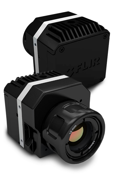
flirVue-profile-collage

FLIR Systems, Inc. (NASDAQ: FLIR) announced the newest member of FLIR Vue™ thermal imaging camera series for unmanned aircraft, the FLIR Vue Pro. Following the introduction of the popular FLIR Vue earlier in 2015, the new FLIR Vue Pro delivers expanded capabilities to sUAS operators by delivering precision thermal imaging, enhanced data collection capabilities, in-flight control of a variety of camera functions, and easy set-up with mobile apps.

In addition to providing the same easy power-in/analog video-out connection that has been so popular on the FLIR Vue, the FLIR Vue Pro records digital thermal video, along with thermal still images, to an on-board micro-SD card. For applications such as electrical inspection, infrastructure assessment, and precision mapping, this on-board recording allows operators to capture thermal data for later analysis. Video files can be recorded in either MJPEG or H.264 format, while the 14-bit still images provide high dynamic range imagery for mapping and survey applications.

The Accessory Port gives users direct control of camera functions like changing the image’s color palettes, starting and stopping recording, and the camera’s e-zoom, making the Vue Pro much more flexible and capable of adapting to mission requirements in flight. With MAVLink compatibility, the FLIR Vue Pro interfaces easily with the standard flight control systems used for mapping, survey, and precision agriculture missions. It can be configured to automatically capture images and annotate each image with the aircraft’s position and other critical flight information. These images are then instantly compatible with leading imaging stitching and orthomosaic-creation software like Pix4Dmapper.

“Building on the pioneering of the original FLIR Vue, the FLIR Vue Pro puts even more thermal imaging   functionality and greater flexibility in the hands of sUAS operators,” said Jeff Frank, FLIR’s Senior Vice President for Product Strategy. “The Vue Pro enables commercial drone operators to provide clients with the actionable, temperature-based data to increase efficiency and improve critical business decisions.”

As a result of the FLIR Vue Pro’s Bluetooth interface with a custom app available for iOS and Android devices, camera set-up is easy for both professionals and hobbyists.  Through the FLIR Vue Pro app, operators can configure functions to ensure the best imagery possible for their conditions without having to connect the camera to a computer.

The FLIR Vue Pro has been recognized as a recipient of a 2015 IoT Evolution Drone Innovation Award and is being showcased at Interdrone in Las Vegas from September 9th to September 11th.  It will be available to purchase later in 2015 from FLIR.com as well as through international drone camera dealers.  Pricing for the FLIR Vue Pro begins at $1,999.


To learn more about the FLIR Vue Pro, please visit www.flir.com/flirvue.

Aerial MOB, LLC Announces Alliance With Panavision

mob-logo-wide-1

Aerial MOB, LLC, a leader in UAS (drone) aerial technology, has reached an exclusive agreement with Panavision, the entertainment industry’s leading supplier of cinema lenses and camera systems. Panavision will recommend Aerial MOB as their preferred drone company in the United States.

Filmmakers can now utilize the capabilities of the industry’s leading FAA-approved drone cinematography company, alongside the industry’s most trusted, state-of-the-art cinema lenses and high precision camera systems.

“Aerial MOB is very excited and honored to be forming this alliance with Panavision,” says Tony Carmean, Chief Marketing Officer and Co-Founder, Aerial MOB. “We will now be able to utilize the most innovative lens and camera systems with our ultra-high-tech drone platforms, offering filmmakers a combined aerospace technology package unmatched in the motion picture industry.”

“We consistently strive to support our customers with the latest creative tools and services, and aligning with Aerial MOB meets that objective,” says Panavision’s Bob Harvey, EVP Global Sales and Marketing. “Their focus on providing advanced aerial technology, with an emphasis on safety and performance, forms a natural alliance of our two companies by providing our clients with the best filmmaking experience.”

Aerial MOB was the pioneer in the development of UAS safety standards with the Motion Picture Association of America and the Federal Aviation Administration. In September 2014, Aerial MOB became the first company in the U.S. to gain FAA approval for use of drones for film production.

About Aerial MOB

Aerial MOB is the leading company in the use of unmanned aerial systems (drones) in film and television production. Utilizing state-of-the-art UAS technology combined with highly cinematic camera/lens systems and the most advanced camera stabilization systems, Aerial MOB is a an innovator in capturing low altitude aerial perspectives.

For more information, visit http://www.AerialMOB.com/pr,

Agricultural drone video systems (DVS) will help farmers soar to success

walkeraforag

AMHERST, NEW YORK, September 9, 2015 – Agricultural drones are revolutionizing modern farming practices by providing crucial data that was previously unattainable or had taken hours to collect by foot. Stampede, North America’s largest distributor of drone-based systems, is taking the agricultural drone revolution even farther with the next wave of drone technology- Drone Video Systems, a new category comprised of drone hardware, video conferencing software, and expert consultative services- that’s bound to reform, once again, how farmers monitor crops and share data.

“Thanks to the Federal Aviation Administration’s Section 333 exemption that allows commercial businesses to fly drones on a case-by-case basis, UAVs already play a significant role in collecting information that helps produce a healthier crop yield,” said Stampede COO & President Kevin Kelly. “Drone Video Systems (DVS) amplify that experience. With the category’s introduction, farmers, regardless of their physical location, can tap into live video feed – captured by the unique and previously unattainable perspective of a drone – and collaboratively assess a situation to make smarter decisions, faster and more cost-effectively than ever before. Anyone they choose can have access to the same data, regardless of location.”

The revolution that’s sweeping the modern farming industry- commonly referred to as “precision agriculture”- is a significant one. According to the Boston Globe, the United Nations, assuming that the global population will reach 9.1 billion people in 2050, projects that food production will need to rise by about 70 percent to feed everyone. Thus, improving crop yield is key to feeding the world. That’s where drones come in.

Not only do agricultural drones save farmers a significant amount of time monitoring acres by foot, but they also provide enhanced data that is otherwise undetectable by eye. Through precision agriculture, farmers can detect differences in yield while harvesting, measure the chemical structure of soil, forecast future seasonal weather, and more.

According to the Daily Press, agricultural drones utilize a 360-degree aerial camera to capture images, which are then sorted with software to develop a complete picture of a farmer’s crops. Aerial images captured from the drone are then layered with satellite data- in addition to data from ground-based sources such as soil moisture sensors and weather stations- to compile digitized multispectral imagery of farm fields. “Drones, and now Drone Video Systems, change the game completely,” Kelly added. “Gone are the days when a farmer had to traverse acres by foot to check on his crops and inform others, much later, on what he saw.”

Measurements in the form of Normalized Difference Vegetation Index (NDVI) images, according to the Boston Globe, assess crop productivity based on visible and infrared radiation. An agricultural drone’s software can take these images, then stitch them together to create a complete picture of the crop’s status.

“Agricultural Drone Video Systems (DVS) are specifically customizable to the farmer’s needs, with a 360-degree camera and the ability to capture wide range of data,” Kelly added. “Farmers can share this data simultaneously with anyone in the world, which is, up until now, unprecedented. The implications for this kind of data-sharing are enormous.”

“High tech” farms are bound to feed more people and reap a greater annual gross income for farmers. According toNational Geographic, farmers that used guiding systems and variable rate technologies reaped significant monetary benefits annually; small farms saw an average gross annual benefit of $11,000, typical size farms saw an average gross annual benefit of $26,000, and large farms saw an average gross annual benefit of $39,000.

“High-tech farming is the future,” Kelly emphasized, “and Drone Video Systems (DVS) provide a revolutionary combination of customizable hardware, video conferencing software, and expert consult services for farmers who want to collect highly specialized data and share it with others simultaneously,” Kelly added. “We’re on the precipice of our next great communication revolution – and, like its predecessors, it’s going to change everything again.”

http://www.suasnews.com/2015/09/38393/agricultural-drone-video-systems-dvs-will-help-farmers-soar-to-success/

Skyward launches the first information management solution for commercial drone operators

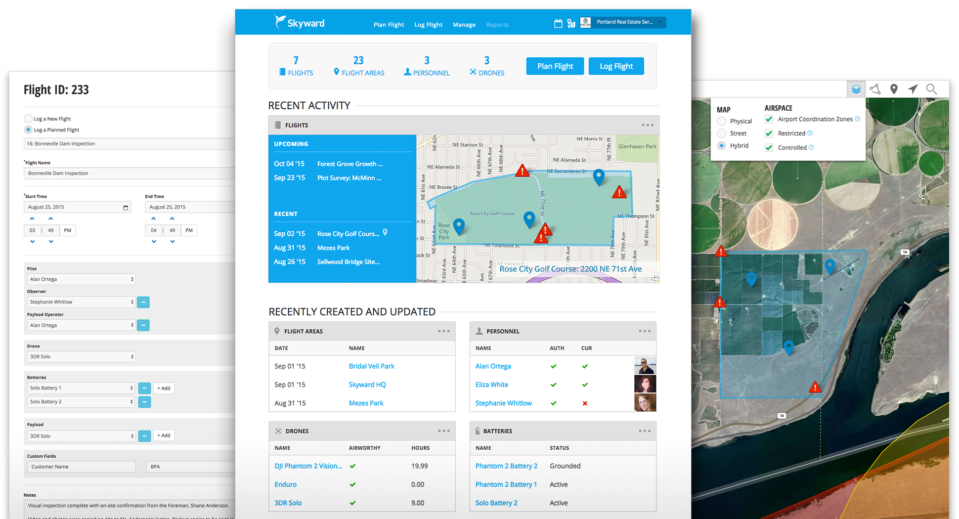
Skyward_demo3_Screenshot-3up-2

Skyward introduced its information management solution, the first designed for commercial drone operators. By providing this critical business infrastructure, Skyward is powering a global aerial robotics network. The cloud­based solution integrates a drone airspace map with flight planning tools and a digital system of record, supported by a team of regulatory and operational experts.

“In the last year, I’ve seen the commercial drone market evolve rapidly, with over 1400 FAA grants to date. Skyward gives those operators comprehensive tools to access the sky and meet their business objectives. Skyward is committed to powering the next generation of aviation,” said Jonathan Evans, Skyward CEO.

“Hawk Aerial needs a system to schedule, track and document our flight operations. Skyward is that system: comprehensive, easy to use, intuitive. Skyward allows us to conform to the requirements of our 333 and COAs, and also provides critical operating data to track performance and profitably run our business. Skyward is key to our future growth.” said, Kevin Gould, Hawk Aerial CEO.

Regulators and insurers across the world need to know the who, what, when, where, and how for flight operations. Skyward is the first integrated solution to address this need for drones, and makes it easy for operators to track the specific information and airspace data needed for business, insurance or regulatory requirements. Over 150 operators are already using Skyward in the US, Canada, Caribbean, Australia, and South Africa, for applications like agriculture, industrial inspection, construction, oil and gas surveying, as well as real estate and cinematography. Skyward is a partner in NASA’s UTM program, and a board member of the SUAV Coalition, working with Verizon, Amazon, Google and others to define the future of this industry.

“As the leading provider of UAS insurance in the US, we’ve recognized the overwhelming need for a complete flight management system,” said Terry Miller, President of Transport Risk Management. “Skyward developed the solution we’ve been searching for, and we will be incorporating it into our insurance underwriting process.”

Key features of the Skyward solution include:

● A drone airspace map ​that simplifies complex aviation rules to show operators where to fly

● Flight planning and logging, c​onfigured for specific requirements

● Digital system of record ​manages personnel, drones, and equipment

● Online storage​for regulatory, insurance, and operational documents

● Support from regulatory and operational experts​for approvals, compliance and reporting

“Skyward is built to power commercial drone businesses. Existing maps and apps built for hobbyists don’t meet the requirements of a professional operation,” said Evans. “Skyward is the one solution a drone operator needs to navigate the new rules of the sky and run their business.”

Commercial drone operators can sign up for a free six week trial at https://app.skyward.io

http://www.suasnews.com/2015/09/38394/skyward-launches-the-first-information-management-solution-for-commercial-drone-operators/


UK: Michael Portillo caught up in drone drama on vintage ship at Pier Head

DRONE-copy

Ex-Defence Secretary Michael Portillo was in the line of fire when a mid-air drone camera crashed into a vintage cruise ship sailing from Liverpool’s Pier Head.

He was on board the MV Balmoral as it left on Sunday morning, to film scenes for his new documentary – The Enemy Files – on the 1916 Irish Easter Rising.

But as he positioned himself on the stern for the clinching shots alongside the Liver Buildings, the circling and recording drone suddenly went AWOL.

The mini electronic helicopter nosedived into a flagpole, and ricocheted onto a senior deck hand, as he tried to throw himself out the way.

Passenger Kenneth Ford was on the Balmoral with his wife, enjoying a trip from Liverpool to Llandudno in north Wales, and watched the drama unfold.

The 76-year-old, from Haydock, Merseyside, said: “Portillo was on the ship with all his camera crew entourage.

“We could see the drone circling in the sky above us, but it all went wrong when it came down, and got entangled in the stern flag, and took out one of the crew men.

“It was pretty chaotic.”

Paul Doubler, spokesman for the Balmoral, said: “The drone was supposed to film Portillo on the stern, but it collided with the shop, and bounced off our bosun.

“He was fine in the end, and no member of public was hurt.

“We’re disappointed this happened.”

http://www.liverpoolecho.co.uk/news/liverpool-news/michael-portillo-caught-up-drone-10017908#ICID=FB-Liv-main

UT: Drone sighting grounds aerial attack of 600-acre Wasatch Co. wildfire

Jeffrey D. Allred/Deseret News

By Ben Lockhart


10PM: Drone sighting grounds aerial attack of 600-acre Wasatch Co. wildfire
6PM: Human-caused wildfire in Wasatch Co. surpasses 500 acres
5PM: Human-caused wildfire in Wasatch Co. surpasses 500 acres
6PM: Oak Grove fire

DEER CREEK STATE PARK — A human-caused wildfire raging near Deer Creek Reservoir in Wasatch County continued to grow Tuesday, reaching 600 acres as fire crews battled canyon winds and tried to wrest control over the blaze.

The Wheeler Fire remained about 5 percent contained Tuesday night, unchanged from late Monday, said Mike Eriksson, spokesman for the Utah Division of Forestry, Fire and State Lands. The fire was not threatening homes or businesses.

Eriksson said fire crews were wary of strong canyon winds spreading the wildfire. High temperatures, dry conditions and rugged terrain were also making the fire difficult to combat, he said.

About 230 firefighters were fighting the blaze late Tuesday. Helicopters used water from Deer Creek Reservoir to dump water over the flames, before a drone sighting Tuesday evening caused all firefighting aircraft to be grounded for the day.

“It’s really unsafe; it can cause safety issues for our aviation folks and for our (crews) on the ground,” said Kim Osborn, U.S. Forest Service spokeswoman.

Osborn said she anticipated helicopters will fight the fire from the air again beginning Wednesday morning, barring another drone sighting. The Wasatch County Sheriff’s Office continued to look for the pilot of the drone in question and asked anyone with information about the case to call their agency at 435-654-1411.

Fire investigators believe the wildfire is human-caused, but Eriksson said exactly what ignited it is still being determined. Wasatch County Sheriff Todd Bonner has said authorities were trying to determine whether an ATV that burned in the fire may have been related to the cause.

Nearby state Route 92 was closed to through traffic.

“We don’t want people to put themselves in a place where there might be a compromise to their safety,” Bonner said.

Winds pushed the fire gradually away from residents of the small Canyon Meadows subdivision about a mile away, but residents there were put on alert.

Jay Gould, who lives in a tiny nearby community called Riverbend, was kayaking Monday when he first noticed smoke from the Wheeler Fire. He and his neighbors are worried about the fire’s proximity, Gould said.

“We’re obviously concerned about it. About 4 a.m. I woke up with my eyes burning,” he said. “You just wonder which direction it’s going to go.”

Pine Valley fire

Meanwhile, a wildfire in southern Utah quickly spread to 300 acres after igniting Tuesday afternoon. Oak Grove Campground near the small town of Leeds in Washington County was evacuated because of the fire, said U.S. Forest Service spokeswoman Marcia Gilles.

Lightning sparked the blazes, Gilles said. None of the fire was contained Tuesday evening.

Four engines from federal and state agencies were immediately sent to the fire. Five aircraft, including a supervising plane, and three additional ground units were also requested to assist.

No buildings were threatened by the fire, dubbed the Oak Grove Fire. It is located on steep terrain, which quickly created problems for responding firefighters, Gilles said.

Contributing: Geoff Liesik, Ashley Kewish

American Family Insurance Director cites three reasons for drones

  • Aerobotika Aerial Intelligence is a Canadian-based UAV flight and pilot training firm. According to Ryan Rist, director of innovation for American Family Insurance, the company will need to find a way to train claims adjusters in the future.
    PHOTO: AEROBOTIKA AERIAL INTELLIGENCE

Ryan Rist, American Family Insurance’s director of innovation, sees three reasons why his company has chosen to invest and now deploy small unmanned aircraft vehicles (UAVs).

After working through research efforts and implementation protocols for the past two years, it has now become clear to Rist’s team that drones are necessary to first, provide faster information gathering through a rapid deployment option, second, ensure quality data is captured of a scene in question, and third, because drones are lower cost options than other means used for information gathering currently available to insurance teams.

For Rist, a perfect example of how drones can increase AFI’s ability to help its customers is after a disaster such as a tornado. “We could deploy drones that next morning or shortly thereafter as we could couple that with our GIS technology and our weather technology. We could then take that data and go to find customers before they come to us. We could proactively show up on their doorsteps,” he said.

AFI’s interest in drones and proactive customer support relates to its emphasis on implementing new technology, Rist said. “This is a great example of how we can invest in and stay on top of these early stage technologies.”

Since AFI first started following drones, Rist said the company has seen great change in the price point for platforms and payloads. “A few years ago,” Rist said, “a drone that was $50,000 is now $5,000.”

Although Rist and his team recently received a U.S. Federal Aviation Administration section 333 exemption to fly for commercial purposes, Rist said the team is still working on how to implement drones in its efforts. “I think we still have to educate the population on how and why we are using them,” he said. Rist wants his customers to know that they value individual privacy and will only be flying to gather information for helping to speed up claims and provide better insurance to its customers.

Before that happens, however, he notes that claims adjusters will need to be trained. “Hopefully there is something in the future to get our adjusters trained,” he said. AFI will begin testing drones later this fall.

http://www.uasmagazine.com/articles/1227/american-family-insurance-director-cites-three-reasons-for-drones

UK: Toy helicopter to blame for blaze which hospitalised a woman and two children

MKfire

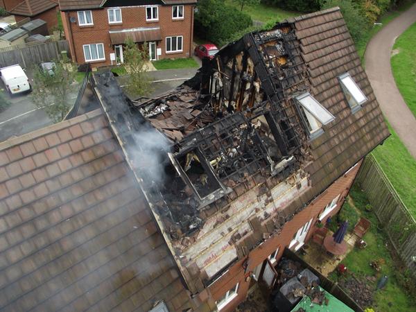
A woman, young boy and baby girl have been taken to hospital following this morning’s house fire in Monkston Park which is believed to have been caused by a toy helicopter on charge.

Three homes were caught up in the blaze which saw the roof of one of the two-storey terraced houses on Finsbury Chase collapse.

Neighbours say they took in three families whose homes were affected.

One said: “Three families live in that block of houses. They’ve been taken in by neighbours. We’re a tight-knit bunch around here.”

Crews from Bletchley, Broughton and Great Holm arrived at the scene at at around 8am with three fire engines and a turntable ladder.

And an update from Bucks Fire and Rescue Service on Twitter just before 2pm, said an electric toy helicopter being charged was ‘believed’ to be the cause.


http://www.miltonkeynes.co.uk/news/local/video-toy-helicopter-to-blame-for-blaze-which-hospitalised-a-woman-and-two-children-1-6945701

VA: Medical Helicopter Pilots Make Plea to Drone Operators

lifeguardheli

By Angela Hatcher

Roanoke, VA – Two close calls prompted the Carilion Clinic Life-Guard team to hold a media event in Roanoke.  Helicopter pilots pleaded with drone operators to stay out of landing zones.

Drones ended up in Life-Guard helicopter landing zones on two separate occasions in the last six months.

A Life-Guard 10 pilot says drones pose a major mid-air threat.

“It could hit a rotor blade and definitely take it out of the air.  It could hit the tail rotor,” said Life-Guard 10 Pilot Bob Bolton.  “It could hit the front windscreen and come right through the windscreen and incapacitate the pilot.”

One of the recent close calls happened on an accident scene in daylight.  The other was at night near a hospital helipad.

http://www.wset.com/story/29983911/medical-helicopter-pilots-make-plea-to-drone-operator

EagleView Welcomes Parchment as VP of Drone Product Strategy

eagleview

EagleView Technology Corporation, an aerial imagery, data analytics and GIS solutions technology provider, named Antony Parchment vice president of Drone Product Strategy.

Parchment will lead the development and implementation of a product strategy that commercializes drone technology and provides scalable and industry-specific solutions across multiple verticals. His initial focus will be to develop products and strategy for the use of drone technologies and data in insurance claims and underwriting.

Parchment joins EagleView after running the Claims Innovation Research and Development team at Liberty Mutual Insurance. This progressive team identified, developed and deployed technologies that reduced Liberty Mutual’s losses and expenses while also developing a ground-breaking strategy for operationalizing drones. Prior to working at Liberty Mutual, Parchment spent 20 years leading software development teams in the development of digital products for Fortune 100 clients across various industries including automotive, financial services, telecom and retail.

As founder of the Property Drone Consortium, EagleView continues to play a leading role in advancing drone adoption by focusing resources and talent on developing industry specific workflows, data analysis tools and infrastructure to facilitate the extraction and conveyance of meaningful and actionable insights from data obtained by UAS.