YUNEEC FTW: YUNEEC announce launch of Tornado H920

tornadoH920

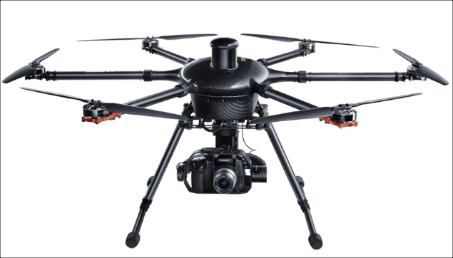
Yuneec International, the world leader in electric aviation, today announced the launch of the Tornado H920 hexacopter and the CGO4 professional gimbal camera. The Tornado H920, the first release from the highly-anticipated Tornado series, is an aerial photography and videography platform designed with the professional user in mind.

The Tornado H920 aircraft features an ultra-lightweight carbon fiber frame, retractable landing gear, folding arms & 5-Motor failsafe mode, making it the solution of choice for professional users. The built-in capability to hold three rechargeable batteries provides consumers with a flight time of up to 42 minutes depending on payload.

Additionally, the Tornado H920 has several smart features that ensure safety and ease of use, which consumers have come to expect from Yuneec International products. Features such as Return-to-Home, auto landing and five-rotor flight safety are built into the Tornado system.

“The Tornado H920 has been specially designed for the high level photographer and is the perfect aerial photography solution for use in multiple verticals,” said Tian Yu, CEO of Yuneec USA. “Professional photographers will get a valuable tool that will help them with work opportunities such as inspections and project surveying and hobbyists alike will enjoy a remote hexacopter that can film everything from weddings to birthday parties to sporting events.”

The ST24 personal ground station, a 24-channel all-in-one transmitter, is powered by an Android operating system and features a 7-inch touchscreen that displays telemetry data and a built-in flight simulator. Consumers will also benefit from the GPS receiver that is the top of the line in its class.

The Tornado H920 is compatible with a variety of independent high-end professional aerial and ground capturing cameras including the all-new CGO4 gimbal camera. Specifically developed for the Tornado H920 copter, the CGO4 incorporates a true Panasonic GH4 micro four thirds camera sensor with a 3x optical zoom lens, an integrated 5.8 GHz video link module designed to capture the highest quality aerial photographic and video imagery, conveniently housed within a precise and ultra-stable 3-axis gimbal system.

Additionally, the Tornado H920 also pairs with Yuneec’s V18 professional gimbal stabilized camera with 18X optical zoom and for further convenience, the Tornado H920 is also compatible with the Panasonic GH4 and Sony A7Rii using the 360-degree panorama capable GB603 gimbal.

The ready-to-fly (RTF) Tornado H920 package includes a travel case, the ST24 personal ground station, Proaction grip for stable ground footage, two batteries and a premium two-port charger for the suggested retail price of $4999.99USD. Camera accessories are sold separately for additional costs. For more information visit www.yuneec.com

http://www.suasnews.com/2015/09/38471/yuneec-anounce-launch-of-tornado-h920/

InterDrone Put the World’s Greatest Drone Photographers Under One Roof

Aerial imaging is having a moment. These are the artists behind the renaissance.

This week marks the 2015 InterDrone Conference in Las Vegas, where experts, industry moguls, and just plain old enthusiasts from around the country come together to talk the wondrous world of UAVs.

The point of the spear, as far as popularizing drones goes, is aerial photography. UAVs give artists the opportunity to rotor their way to new perspectives and sweeping views. Images taken from height have revolutionized how we consider war, agriculture, and even shipping, but sometimes they are — more than anything — beautiful. And the authors of that beauty were at InterDrone this week to speak about their emerging art form and push for further innovation.

These are the pilots leading the photographic charge.

Randy Jay Braun

Braun is DJI’s director of product experience. The Maui-based photographer has worked with drones for 30 years. Although commercial drones are fairly new, Braun has been at it for long enough that he literally wrote the book, Aerial Drone Photography.

Eric Cheng

The award-winning San Francisco-based photographer has placed his work in many outlets, ranging from Wired to The Washington Post and The Wall Street Journal. Cheng has had his hand in drone photography since the early days, consulting with engineers to create photo-ready fliers.

Parker Gyokeres

Gyokeres is the owner, pilot, and overall man-in-charge of Propellerheads, an aerial photography company that offers services to businesses and individuals around the world. He’s a former U.S. Air Force Photojournalist, so certainly piloting a drone in the air to snap a couple of images is hardly a feat. But as you can see through his work, Gyokeres is quite good at what he does.

Dronestagram

Now Dronestragram isn’t a person — it’s a website founded by French entrepreneur Eric Dupin, who’s at InterDrone as a judge for the conference’s film festival.

Cape Kamui, Japan

Cape Kamui, Japan

Dronestagram compiles user-submitted drone pictures from amateur photographers all around the world. It’s definitely a site worth keeping up with, especially if you’re looking to break into aerial photography and want to get in touch with a community that can help you hit the ground running.

Xago, Gozon, Asturias, Spain

Xago, Gozon, Asturias, Spain

So Dupin isn’t technically a photographer, and chances are most of the photographers who’ve submitted to Dronestagram are probably not at InterDrone. But we’d definitely be remiss not to show you guys some of the glorious pics found on the site.

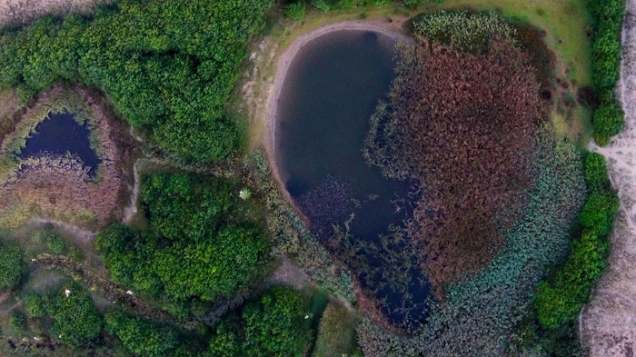
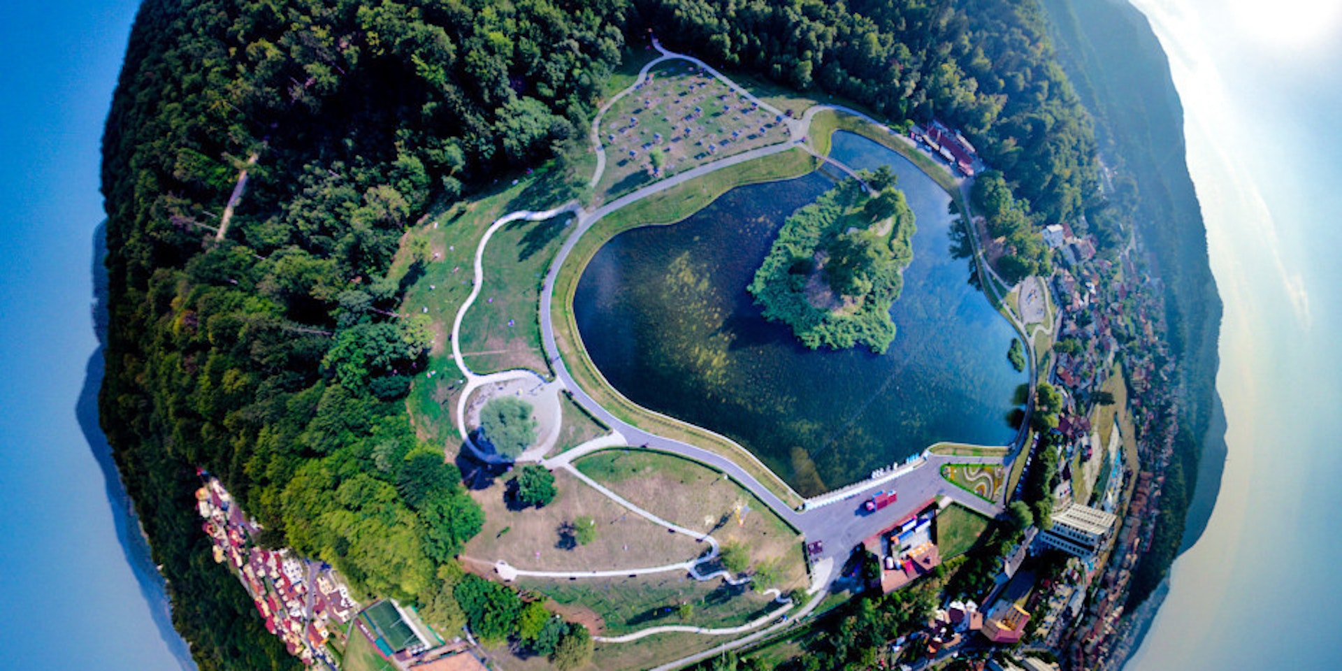
Lake New, Romania

Lake New, Romania

Photos via Parker Gyokeres and  Hirokatsu Seki and belovez and thedon and Giannis Zarzonis

Neel is a science and tech journalist from New York City, reporting on everything from brain-eating amoebas to space lasers used to zap debris out of orbit, for places like Popular Science and WIRED. He’s addicted to black coffee, old pinball machines, and terrible dive bars.

https://www.inverse.com/article/6079-interdrone-put-the-world-s-greatest-drone-photographers-under-one-roof

Get Anything Filmed By a Drone Pilot

Get Anything Filmed By a Drone Pilot

Wedding? Mountain climb? Drone-assisted proposal? Drones.io has your aerial filming needs covered

Jeb Brack

You’re a realtor, and you think some aerial photography would be just the thing to showcase your latest property. Or maybe you’re getting married, and some shots from above will make the day more memorable. Or suppose you’re producing an independent film and you need some dramatic video to add production value. Until the age of Unmanned Aerial Vehicles, aerial photography was beyond the budgets of most people, but now clients can find the perfect drone pilot for their project with Droners.io.

cabin.jpg

Drone pilots and photographers from all over the country post their profiles and portfolios on Droners.io, describing what kinds of jobs they can do. Prospective clients post a job listing, including relevant information such as dates, locations, and especially the type of job. The site includes several categories: weddings, events, real estate, construction, inspection, boating and water sports, TV and film production, and others. Once the job is posted, pilots can respond with their bid and clients can see their past work before making a choice.

Screen Shot 2015-09-11 at 12.45.40 PM

Secure payment is made through the website as well, depending on the agreement made with the pilot. If you’re interested in flying drones, you can shop for instructors on the site as well.

slackliner2.jpg

Droners.io reports that they have over 700 pilots and companies signed up on the site. While the most frequent clients are realtors and weddings, new and creative uses for UAVs appear all the time.

One job listing asked, “Looking to go on a hike with my girlfriend and have a Drone come out of no where (in a designated spot) and have a drone come close enough to where I may grab the ring box and propose, while the drone continues to catch all the action on film.”

So if you have a wild idea that could use a drone, post a job listing and see if there’s a pilot out there for you.

Droners.io

http://www.psfk.com/2015/09/filmed-by-a-drone-pilot-drones-io-aerial-photography.html


CBC: Flying drones may emerge as integral farming tool

Air-to-tractor communication can automatically adjust fertilizer amounts

By Nicole Kitchener

Evan MacDonald, owner of Island Aerial Imagery, says flying drone technology can help farmers improve crops and reduce the amount of fertilizer they use.

Evan MacDonald, owner of Island Aerial Imagery, says flying drone technology can help farmers improve crops and reduce the amount of fertilizer they use. (Brian Higgins/CBC)es

Flying drones may become a useful technology for Prince Edward Island farmers who are looking for ways to use fewer chemicals on their fields.

A flying drone was high above a Spring Valley potato field Friday as part of a 4-R Nutrient Stewardship demonstration.

This group of farmers are interested in better managing their crops while protecting the environment at the same time.

Images transmitted from the drone will show the farmer the healthy and unhealthy parts of the crops. A map created by the drone can be programmed into the GPS on a farmer’s tractor which, in turn, will automatically adjust how much fertilizer is applied.

“I hope it can eventually save potato farmers some money on inputs and just make smarter decisions overall and that will only lead only to improvement in the environment as well,” said Evan MacDonald, owner of Island Aerial Imagery who demonstrated the technology.

Flying drone image of P.E.I. potato field

A near-infrared image captured by a flying drone over a P.E.I. potato field. Vegetation is picked up as a reddish colour, water and everything non-vegetative stays its normal colour. (Island Aerial Imagery)

The goal is to use less fertilizer and reduce nitrate levels in P.E.I. groundwater.

“Anything that can help us scout a field or see what’s happening before we actually see it with our own eyes, it would certainly be a big advantage to us,” said Allan Waugh, who grows potatoes in North Bedeque.

“It’s new technology. We’ve always got to be going forward, so we have to certainly take a look at it.”

Potato growers in the western United States now use drones to scout fields.

The nutrient stewardship program will be testing the technology on P.E.I. fields in years to come.

http://www.cbc.ca/news/canada/prince-edward-island/flying-drones-farming-pei-1.3225099

Drones to keep vigil on Panipat-Jalandhar oil pipelines

pipeline

Alarmed over increasing threats from the well-organised gangs of oil thieves, the Indian Oil Corporation (IOC), nation’s largest public sector oil corporation, has decided to rope in an unmanned aerial vehicle (UAV) for effective surveillance of its underground pipelines. Official sources claim that the initiative would be the first of its kind in the country where a drone would be used for such surveillance.

“IOC will use the hi-tech aerial surveillance for next few months on a pilot basis on Panipat-Jalandhar pipeline. If it gives desired results, similar initiatives may be extended for surveillance of other pipeline networks in the country,” chief spokesperson of Panipat-based IOC refinery N Shiva Kumar told Hindustan Times on Wednesday. He said that the drone would help in giving a real-time information in case of pilferage or any untoward situation in the pipeline network

Pilferage

On August 4, a case was detected at Begumpur village in Karnal district where the accused had dug a tunnel to pilfer diesel from the underground pipeline. It was stated to be a second such case in the country where criminals had used sophisticated techniques to puncture the pipeline in a concealed manner. Police sources said that a total of 92 cases of oil theft had been reported from Haryana since IOC refinery in Panipat was established in 1998. Sources said that IOC suffered huge losses due to the incidents of pilferage.

However, undermining the financial losses incurred in oil thefts, the public sector company said that safety of human lives and environment was of much higher importance for them. “Plugging oil pilferage is certainly significant but any incident of leakage and sabotage can lead to losses beyond imagination. It is certainly a matter of concern when a gang dug a tunnel and stole oil. IOC wants to give a firm answer to such instances,” said Shiva Kumar. Most of the pilferage sites were located in agriculture fields, near abandoned water drains, panchayat grounds and forest lands.

IOC said that if pilferages go wrong, they could be a great safety and fire hazard and create heavy environmental pollution, damage to water bodies, spoil natural drinking water facilities, soil and could be harmful to even public property and human life.

“Interruption in supply of petroleum products for civilian and defence requirements would be drastically hampered in case of any damage to the supply line,” he said.

Monitoring

IOC’s Panipat refinery has a control room which monitors pressure in the pipelines roundthe-clock. Lowering pressures of refined petroleum products means theft or leakage in the pipeline due to other reasons.

“It is always a challenge to identify the exact spot and reach there in time. As per the proposal, a drone would be taken to the disturbed spot by road and it would be commissioned for aerial surveillance. It would have a potential to hover about 500-metre from ground, besides having nightvision facility. The GPS connectivity will immediately transmit data to our surveillance team,” said the spokesperson.

Internal inspection tool

IOC is also using instrumented Pipeline Inspection Gauge (i-PIG) high-tech gadget to supervise the internal health of pipelines.

A round-shaped gadget that runs inside the pipeline, i-PIG had helped the IOC in the recent case of pilferage in Karnal where oil was stolen by digging a long tunnel.

“Developed by Bhabha Atomic Research Centre, i-PIG is used to clear impurities for smooth flow of petroleum products. As the gadget contains a camera, technical experts can take full assessment of pipeline and specific point where it is punctured. As its success was experienced recently, i-PIG and UAV can together assist us from internal and aerial monitoring,” said Shiva Kumar.
Modus operandi of oil thieves

IOC officials observe that welltrained people are engaged in oil theft cases. Sources said that normally pipeline is drilled randomly with the help of high-precision tools and fix a valve in the underground to steal petroleum products. “Since the pipelines are four-five feet below surface, one cannot easily identify the underground pipes. Miscreants locate oil networks with the help of caution markers and make a blind try on the pipe to extract oils. Once succeeded, the miscreants start taking out oil for days together in small quantity as it not possible for anyone to handle petroleum products flowing at such a high pressure,” the sources said.

Police sources said that according to a rough estimate, thieves have extracted oil to the tune of several lakhs of rupees.

http://www.hindustantimes.com/chandigarh/drones-to-keep-vigil-on-panipat-jalandhar-oil-pipelines/article1-1389106.aspx?utm_content=buffer93ef2&utm_medium=social&utm_source=twitter.com&utm_campaign=buffer

KY: Student charged with wanton endangerment after drone crash

UKstadium

Associated Press Writer Bruce Schreiner in Louisville, Kentucky

Kentucky campus police have charged law student Peyton Wilson with second degree wanton endangerment for operating a drone that crashed into a section of Commonwealth Stadium before theWildcats’ season-opening football game against Louisiana-Lafayette.

The school also says it has forwarded its findings to the Federal Aviation Administration for further review.

Wilson, 24, of Louisville, Kentucky, was operating the unmanned aircraft outside the remodeled stadium Saturday night before it crashed into suite-level glass on the south side. UK police chief Joe Monroe said Friday morning in a news conference that the drone had a high-powered camera attached and that Wilson was flying it for personal or possible commercial use.

“We don’t feel like it was a prank,” said Monroe, adding that police had recovered images from the camera.

Monroe also said Wilson had flown the drone over other campus sporting events, including a soccer game last Friday night. But the aircraft’s most recent flight caused concern on a night filled with excitement as the Wildcats unveiled the “new” Commonwealth after a $120 million renovation.

The drone hovered close by military skydivers parachuting into the packed stadium with American flags. One of the skydivers told police he had to take evasive measures to avoid the drone, which came within 20 feet of his parachute.

No one was injured, and the stadium wasn’t damaged.

“It’s very dangerous when you have a remote controlled, non-piloted aircraft that’s flying in areas where there’s lots of people,” Monroe added.

Wilson was cited to appear in court for the misdemeanor charge punishable by a year in jail and a fine. Any discipline by UK would be handled by the school’s student code of conduct violation office.

The Associated Press called a relative of Wilson, who had no comment and didn’t want to be identified. The relative had spoken with Wilson, who indicated he didn’t want to comment.

The university does not have a written policy banning drones and is studying the issue.

“We hope that this will set a precedent that this is not going to be tolerated at the University of Kentucky in these venues without prior approval,” Monroe said.

FAA policy for airspace around special events such as games restricts flights for three nautical miles and up to 3,000 feet. Safety guidelines for model aircraft suggested on the agency’s website include flying below 400 feet, not flying within five miles of an airport and avoiding “people or stadiums.”

Helipads are considered airspace as well, and Wilson’s drone was within a half-mile of two at nearby UK Chandler and Baptist hospitals, both within walking distance of the stadium. Chandler’s helipad could be seen just beyond where the drone hovered behind a scoreboard above the west end zone.

“This could have caused serious problems for them as well,” said Monroe, adding that school officials will post signs in campus parking lots stating they are no-drone fly zones.

It was the second incident involving a drone at a sports event in the past week.

An unmanned aircraft plummeted into empty seats and caused a scare during a women’s singles match last Thursday night at the U.S. Open. No one was injured, but it broke into pieces as it crashed.

A high school science teacher who had been flying the drone from a park outside the tennis venue was arrested last Friday on reckless endangerment and other charges, police said.

The FAA put drone and model-plane enthusiasts on notice last October that it’s illegal to fly the aircraft near Major League Baseball, NFL and NCAA Division I college football games and major auto races.

The move came months after police detained people for using small drones at Carolina Panthers and University of Texas football games. This past June, police questioned a man flying a drone near a gate at Citizens Bank Park in Philadelphia during a Colorado Rockies-Philadelphia Phillies game.

WSJ: Protect Us From the Game of Drones

concertdrone
By JOE QUEENAN

A few weeks ago I attended a free jazz concert along the banks of the Hudson. The late-summer evening was lovely, the breeze gentle, the music quite pleasant. But at the edge of the park, where people were barbecuing, stood the Guy with the Drone. The dreaded Guy with the Drone.

This was not a guy from the defense department or from Amazon; no, not even a drone pizza-delivery guy. This was just the ordinary and increasingly ubiquitous Guy with the Drone.

As the musicians diligently labored a hundred yards away, working their way through beloved standards, Drone Dude amused all and sundry with the exploits of his mighty spacecraft. The drone went up. The drone went down. The drone went hither and yon and hovered above the assembled multitude. The gentry were beguiled. The tykes were enthralled. The oohs and ahs could be heard miles away.

There were no oohs and ahs from the musicians or from the hard-core jazz aficionados. Jazz musicians have enough problems without having to compete with drones. It’s almost impossible to hold an audience’s attention during an eight-minute bass solo on “Someday My Prince Will Come” while somebody is clowning around with a drone in the vicinity.


http://www.wsj.com/articles/protect-us-from-the-game-of-drones-1441985711

Research Drones Lead to Discoveries at Medieval Irish Sites

finan_aerial_ireland_450Drones have attracted significant attention over the past few years and their application in numerous industries is being discovered. However, drones have found noticeable favor among archeologists due to their ability to capture aerial photography from otherwise challenging angles in a very cost-effective manner.

According to the Saint Louis University history professor Thomas Finan, the application of drones in archeology has become very important because specialized sensors attached to drones can acquire multi-spectral images, which can be processed over mapping software using high speed computers. The significance of drones in archeology came to the foreground when they were used at the Lough Key archaeological site.

Due to the increasing importance of drone technology in archeological discoveries, Finan has entered into a venture with the director of Western Aerial Survey, Paul Naessens, who is also a field archeologist to enhance their exploration endeavors by using drone technology.

According to Finan, a medieval Gaelic settlement was identified in 2013-14, which is close to the Rock of Lough Key. Currently, the archeologist’s team is working on smaller sites surrounding the area, which also include a ringfort which appears to be a medieval settlement. It can be said that with the introduction of drone technology in archeology, the pace and effectiveness of discovering medieval settlements has been significantly enhanced.

Finan is specifically interested in bringing together numerous medieval settlements in an attempt to study the events that took place around the thirteenth century and to understand the social dynamics that prevailed at the time. By studying all these settlements as a whole, the diversity and similarity of the social dynamics will be understood in a better manner. Data collection of archeological sites has become considerably more efficient with the introduction of drones. Thus, we can infer that drone technology has the potential to revolutionize research work in multiple industries including archeology.

http://dronelife.com/2015/09/11/research-drones-lead-to-discoveries-at-medieval-irish-sites/