Mapping out the drone market ecosystem

droneecosystem

After looking into both the VR and IoT space, I wanted to dig in and understand the drone ecosystem and how all of the various players fit together.

Some caveats before we dive into the analysis.

This ecosystem map is not designed to be 100% comprehensive. It’s more to understand all the different spaces within drones.
I am biased towards startups in the space.
If I am missing something tweet me @mccannatron.
This space is developing quickly so take this into consideration.

Observations

  • Drones are hard to categorize. The drones (hardware) themselves are multi purpose and can be used as a tool for any function. I categorized them based on how each drone company talked about themselves on their home page (see the areas under “commercial”).
  • It’s interesting to see a few drone companies verticalize and provide the hardware, tools, software, and analysis for a specific market. For example Sky Futures is for oil and gas, Avetics is for film and photography, etc.
  • It’s interesting to see corporations experiment with drones, most notably in the delivery space. This includes Amazon & Alibaba and also the existing shipping companies: DHL and UPS. One report states that a Chinese Shipping company called SF express is already delivering 500 packages a day via drone. (I can’t tell how believable this is).
  • There is a whole ecosystem developing around the hardware of drones including: insurance, fleet management, marketplaces, data analytics for drone data, etc.
  • Once the long range programmable drones hit widespread adoption in the consumer and enterprise sector, this could be the first inflection point. For example this drone pictured below made by Airborne Drones can fly up to 90 min, is programmable, has a range up to 12 miles, and can carry 17 pounds.

Company observations

Commercial

  • If you are thinking about starting or going into the commercial drone market, I would pay attention to all of the various sub industries within the commercial market. I pulled all of these from the websites of all of the commercial drone companies, on the markets they said they served.
  • Sub industries within Commercial: Agriculture, Construction, Infrastructure, Oil & Gas Utilities, Mining, Inspection, Wildlife, Environment, Humanitarian, Public Safety Mapping, GIS, Surveying, Cinematography, Videography, Advertising, Law Enforcement, and Maritime.

Consumer

Marketplace

Insurance/Education

  • Very interesting to see the big players in insurance — AIG and StateFarm — trying out drone insurance. I’d pay attention to Skyward.
  • DartDrones is one of the few FAA certified drone flight schools. Depending on the FAA regulations and insurance standards, these types of schools could become important.

OS/Deploy Systems/Data

  • DroneDeploy is an operation system for deploying and controlling drones programmatically. I could see them moving into the space Skycatch is in and start providing more of the full drone imaging stack.
  • I would expect many more companies in the drone data/imaging space once the commercial drone sector starts to take off. Mavrx, DroneData, and AirFusion are just the beginning.

https://twitter.com/mccannatron

Will The FAA Soon Regulate UAV Hobbyists?

Will the alarming increase in near misses between manned and unmanned aircraft cause Congress to give the FAA authority to regulate drone hobbyists?

Several months ago, I spoke to an aviation attorney who told me that the Federal Aviation Administration is always seeking to expand its regulatory authority and predicted that the trend would continue with unmanned aerial systems (UAS).

At the time, I didn’t see how the FAA could expand its power a great deal more given that it claimed authority over all U.S. airspace and all aircraft operating in it—manned or unmanned. But in light of the recent increases of close encounters between airliners and drones, it got me to thinking about some of the UAS-related Congressional hearings I’ve seen over the past year.

They almost all included a committee member asking an FAA official what it was doing to protect the flying public from drones. The FAA official would point out that hobbyist operators of unmanned aerial vehicles were likely the culprits, and then tactfully point out that Congress expressly forbids the agency from regulating hobbyist and recreational drone pilots.

Not surprisingly, members of Congress don’t like to hear that they are at least partially to blame for the problem and thus spend little time dwelling on the situation they helped create.

A few weeks ago, another attorney with expertise in UAS law suggested that for reasons of safety, improved regulation and more effective law enforcement, it might be wise to get rid of the distinction between recreational and commercial UAV operators.

Last week while writing a story about the Air Line Pilots Association’s recommendations for improving UAS safety, I noticed that the organization’s white paper was timed to advise members of Congress on what commercial airline pilots hoped would be included in the FAA reauthorization bill known as the Aviation Innovation, Reform and Reauthorization Act (AIRR).

Congress will likely begin hearings on this legislation next month. Although I have yet to hear or see anyone say that the FAA needs increased authority to regulate hobbyists and recreational UAV pilots, I wouldn’t be a bit surprised if the idea is given serious consideration.

Otherwise, members of Congress will continue to hear that the reason the FAA can’t get amateur drone operators under control is because Congress won’t allow it to. And no politician wants to be left holding that particular bag if a collision between a manned and unmanned aircraft becomes a tragedy.

http://www.uasmagazine.com/blog/article/2015/08/will-the-faa-soon-regulate-uav-hobbyists

FAA gives ND expanded UAS flight testing capabilities

  • The FAA authorized North Dakota’s Northern Plains UAS Test Site for night operations and to allow UAV flights statewide above the 200-foot ceiling set for the other five test sites.
    PHOTO: UNIVERSITY OF NORTH DAKOTA

Unmanned aerial systems (UAS) development in North Dakota received a boost from the U.S. Federal Aviation Administration (FAA) this week while also marking the first flight of an unmanned aerial vehicle (UAV) from a general aviation airport.

The FAA gave the Northern Plains UAS Test Site approval to expand operations and night flight testing capabilities throughout the state. The University of North Dakota (UND) last week noted a flight test of the Northrup Grumman SandShark UAV conducted from the Lakota, North Dakota, public airport in conjunction with the Northern Plains UAS Test Site.

The FAA said its expanded authorization for the state was granted under the agency’s Certification of Authorization (COA) process, allowing industry more efficient access to airspace for collaborative research. The FAA said it approved the COA application based on the maturity and the demonstrated safety and operational processes used by the Northern Plains UAS Test Site.

“The addition of night flying opens up the opportunities for industry partners to test sensor payloads in all lighting conditions,” said Robert Becklund, test site executive director.

The Northern Plains UAS Test Site also received a COA that makes the entire state available for testing at altitudes higher than the 200-foot blanket COA issued to five other FAA approved sites. North Dakota is the first test site to be entirely covered by a COA that includes airspace above 200 feet for UAS testing.

The SandShark flight from the Lakota airport was part of a test project jointly funded by Rockwell Collins and the North Dakota Department of Commerce, according to Doug Olsen, project manager and a member of the UND UAS Center team. Rockwell Collins—located in Cedar Rapids, Iowa—is a manufacturer of avionics for manned aircraft and is developing UAV applications of its technologies.

“This was a milestone flight because right now there are no regulations allowing routine UAS flights at U.S. public airports,” said Al Palmer, director of the UND UAS Center of Excellence. “We are working closely with the FAA to ensure we conduct safe operations under our COA at the airport.”

Olson said, “Rockwell chose UND to test this new technology because of our UAS and test site capabilities. While this first flight was for crew currency and aircraft checks, the nature of the project—our objective—is to eventually fly with new Rockwell Collins radio technology to test how well it works, controlling UAS beyond line of sight.”

UND received the SandShark as the result of a cooperative agreement with Northrop Grumman Corp. to provide UAS pilot training to domestic and global customers. The agreement also encourages development of new technologies for UAS using the SandShark.

http://www.uasmagazine.com/articles/1203/faa-gives-nd-expanded-uas-flight-testing-capabilities

Take flight with drone workshops

 LINDA WHITE

Special to Postmedia Network

durham-drones

Retail giant Amazon’s much-publicized plans to launch a drone-based delivery service is still years away but unmanned aerial vehicles (UAVs) are already in our skies and their use goes well beyond the military.

They’re being used to take incredible aerial photography, assist search-and-rescue crews, monitor and inspect everything from mines and crops to wildlife population, and so much more.

Consumers of all stripes are embracing the technology but without training, permits and proper insurance, they’re putting themselves at unnecessary risk, says Marcus Dickinson, CEO at X4 Drones and a UAV instructor who will be offering introductory and advanced workshops at Durham College this fall.

“People rush out there and buy the biggest, most expensive, shiniest drone they can get,” Dickinson says. “The retailer is under no obligation to make sure their customer is not only educated but insured to fly their UAV and hands them these things that are literally flying chainsaws.”

Too often, drone users rely solely on their unit’s autonomous system and don’t understand how factors like solar flare activity can affect a drone’s GPS. “They either lose their unit, crash their unit or hurt somebody or themselves with their unit,” he says.

Dickinson encourages anyone interested in flying a drone to learn how to manually pilot it first. “Master it,” he says. “Then and only then should you be working with a more complex unit.”

Here’s a look at the workshops he will be offering at Durham College:

Drones – Intro to Flight: The hands-on workshop covers the basics of drone operation and principles of UAV flight, including axis of flight control, wind turbulence and the basics of radio frequencies and transmissions.

“You learn how to fly with a qualified instructor who will offer tips and help you get comfortable with the units,” says Dickinson. “These units have no autonomous capabilities — it’s all manual flight.”

UAV Operator Training: Learn about GPS, compass and barometer technology; make use of semi- and full- autonomous unit functionality; and conduct pre- and post-flight safety checklists. Learn about Transport Canada regulations, insurance requirements, privacy law and municipal bylaws to start your own aerial photography and videography business.

“You’re legally allowed to use drones for wedding photography and real estate but you have to be an incorporated business in order to get drone insurance and you cannot apply for a special flight operation certificate from Transport Canada if you don’t have that insurance,” Dickinson says.

The interest in training continues to grow. “We have found a huge market for educating consumers,” he says. “We also do professional services … and are training skilled workforces on how to safely use these things for higher-risk applications.”

Durham College workshops

Drones – Into to Flight: This three-hour hands-on workshop will be held Sept. 19, 2015. Participants must purchase a drone (approximate cost $70), payable to the instructor at the start of class.

Unmanned Aerial Vehicle Operator Training: This three-hour workshop will be held Oct. 19, 2015. A GPS-enabled drone is required as well as safety boots, gloves and glasses. The introduction workshop is a prerequisite.

Visit durhamcollege.ca/coned to learn more.

linda.white@rogers.com

http://www.torontosun.com/2015/08/13/take-flight-with-drone-workshops

Tired of a bad rap (and I’m not talking run DMC)

IMG_9123

It’s a great time to be in the UAS industry. New rigs and accessories are being revealed weekly. If you are reading this article, there’s a good chance you are serious about how you operate whether you are a commercially licensed pilot or a photographer transplant that had to add a UAS to stay ahead of your competition. In either case, to further this industry we must utilize SOP’s (standard operating procedures) and FOM’s (flight operations manuals). Let me explain why.

After 15 years as an ATP licensed pilot and flying airplanes for 26 years, I have checklists and standard operating procedures deeply engrained in my cerebellum. I have applied these to other areas of my life due to their efficiency. For now, lets just look at transportation. Imagine your morning commute, you find the interstate filled with big rigs without brakes doing 180MPH. Sound scary? Well, think about some of the drivers having learner permits, and some who have more experience, all mixed together out there. Wouldn’t you like a little more organization out there? Someone controlling a bit of that? That’s just what our Air Traffic Control system does.

ATC handles around 28,537 commercial flights per day. How do they manage to all operate safely? An airline pilot sometimes meets his copilot minutes before they take a metal tube 36,000 ft in the air at 593.741miles an hour. Standard Operating Procedures is a giant part of those 28,537 successful flights. Because of the SOP’s, both pilots could literally not talk (except for reading the checklist) the entire flight and know what and when the other pilot was going to do the ENTIRE flight.

As I said in the beginning, if you are reading this, you are trying to operate professionally. In order for the general public, clients, and government entities to have confidence in professional UAS operators, we should have these things in place. Not only do they exponentially increase safety, and make things more efficient, but they also show professionalism. Do you currently have a procedure for camera man loss of monitor, bird strike, erratic control issues, securing launch points? Do you operate the same way every time? Do you and your cameraman use headsets? Does your VO know anything about UAS operation? Does your video editor know the order of sent videos? Having SOP’s in place creates efficiency and adds safety to your operations. After all, time is money and we all know what a lack of safety can do to the wallet. Not only that, but this industry certainly does not need anymore help with bad press!

When we, a group of professional commercial pilots, decided to create this company it was natural for us to build the company with the same parameters as the aviation environment we were all familiar with. For example: NO equipment is taken out until a walk around is completed. We mark our launch area with a launch pad and secure our entire flight area so that everyone around is familiar and comfortable with our operation. Our job spec sheet is completed and put on our launch pad before flight so that it gets recorded as we check our controls. So just like any professional aviation operation, anyone of our operators can fly or camera any one of our rigs.

The technology available to us makes creating a safe operation even easier. With all of the software on our smart phones, aircraft specific checklists are easy to create and distribute. Most manufacturers have proposed items and we added important things we felt had been omitted. On the back of our ID’s is a non craft specific checklist, which includes things outside of the UAS. Point being, SOP’s and FOM’s may sound like a bunch of yaya and extra work but really it requires just a little planning and effort to garner a lot of return.

I am not writing this to boast about our operation, but to further this industry. Lets be real, some of our lower margin customers don’t care if we wear a “film crew” labeled vest and operate with SOP’s, but eventually our haphazard non 333 exempt competition may be asked to produce some of this. Why not go ahead and set a new standard? One that sets the real professionals apart. This will not only set you up for success but launch this new drone industry into a good future.

http://www.suasnews.com/2015/08/37783/tired-of-a-bad-rap-and-im-not-talking-run-dmc/

Drone flights overhead cause stress for black bears, study says

mother-bear-and-cub

By Lisa Johnson, CBC News

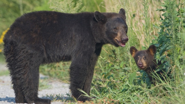
Drones operated by researchers may have unintended consequences for wildlife, warns the lead author of a new study showing the buzzing of unmanned aerial vehicles overhead can leave black bears stressed, with racing hearts.

Researchers flew drones about 20 metres above black bears that were wearing GPS collars and cardiac monitors to measure what effects the unfamiliar noise had on the bears.

Lead author Mark Ditmer said they thought the bears might flee, but they hardly moved at all.

Instead, their heart rates spiked, showing a major stress response.

“For them to mostly stay in one spot, and have this racing heart rate, was a little bit of a surprise for us,” said Ditmer, a postdoctoral researcher in conservation biology at the University of Minnesota who led the study published in Current Biology.

Stress response ‘pretty severe’

The team gathered data on the bears’ movement while the drones flew, with the collars sending a new location every two minutes as the bears ambled through corn fields and aspen forests in northwestern Minnesota.

But they had to wait until the bears were in hibernation before downloading the heart rate data.

The researchers had expected some physiological reaction to the unfamiliar buzzing overhead, but not such a strong response, said Ditmer.

“I couldn’t believe it,” said Ditmer.

“It became strikingly obvious that we were seeing a pretty acute stress response that was pretty severe, at least in some cases.”

In the most extreme case — a mother bear with two cubs — the bear’s heart rate spiked to 400 per cent of her resting rate, jumping from 41 beats per minute before the drone flight to 162 beats per minute when the drone circled overhead.

That kind of stress response, which likely also included a surge of adrenalin and other changes, helps a wild animal in a real emergency, but chronically stressed individuals are more susceptible to disease and other problems, said Ditmer.

‘Cautionary tale’

Ditmer and colleagues wanted to look at the bears’ reaction, because drones are increasingly used in research and conservation — not to mention by hobbyists — with little known about their effects on wildlife.

This study was limited to 18 flights over the four adult bears in a zone where federal rules allowed drone flights. Other types of wildlife would respond differently to the unfamiliar sound of a drone, said Ditmer.

Still, he hopes it’s a “cautionary tale” as drone use increases.

“Just because we’re not noticing an animal changing behaviour, that doesn’t mean there’s not some sort of negative response happening.”

http://www.cbc.ca/news/canada/british-columbia/drone-flights-overhead-cause-stress-for-black-bears-study-says-1.3188549

RCMP investigate after drone nearly hits Eston, Sask. resident

png0925Npolicememorial03

CBC News

RCMP are investigating after a drone reportedly fell out of the sky and nearly hit a person in Eston, Sask. earlier this month.

Police say on Aug. 1, the drone fell into a tree in a backyard and then almost hit someone who lived on the property.

No one was injured and no property was damaged.

Police removed the drone, which is also known as a ‘small unmanned air vehicle’, from the property and put it in a safe area.

RCMP have contacted Transport Canada and the Town of Eston, which is approximately 209 kilometres southwest of Saskatoon.

As the investigation continues, officials are uncertain as to whether or not any charges will be laid.

According to Transport Canada, if the aircraft weighs less than 35 kilograms and is used for recreational purposes, it can be flown without permission.

However there are a number of rules that must be followed. For example, drones cannot be flown closer than 150 metres to people, animals, buildings, structures, or vehicles.

http://www.cbc.ca/news/canada/saskatchewan/rcmp-investigate-after-drone-nearly-hits-eston-sask-resident-1.3190487

Drone Flies Over Brooklyn in NYC’s First FAA-Approved Launch

By SIMONE WILSON

Aerobo, formerly named Aerocine, is one of the biggest players in the burgeoning U.S. drone industry — but until this Thursday afternoon, the Brooklynites who run it had never been approved by the FAA to fly a drone through home skies.

The drone was launched at 5 p.m. near the company’s offices.

“It was right here in Brooklyn — in Industry City,” Jon Ollwerther, head of communications at Aerobo, says in a brief phone interview on Thursday evening, over the roar of a nearby drone.

In an article on the company’s record-breaking flight, the New York Business Journalcalls Aerobo’s co-founders, NYU alumni Brian Streem and Jeff Brink, “Brooklyn’s Wright brothers.”

From the Journal:

The commercial flight is historic in that the company, Aerobo, is the first to be approved by the Federal Aviation Administration, marking the beginning, in a lot of ways, of a whole new industry.

“Though we have conducted many test flights on this airframe and others in our fleet, today is not a test flight, it is for a commercial client,” wrote Jon Ollwerther, vice president of marketing and operations, in an email today to the New York Business Journal. He called commercial drones a potential $20 billion industry.

The drone that Aerobo sent up on Thursday is an Aerobo X8 (approved by the FAA in June) equipped with a camera called RED Epic.

And the ”commercial client” in question is a production company making a film about Brooklyn tech companies, Ollwerther tells Patch.

Aerobo’s drones have completed plenty of FAA-approved flights in other parts of the country, Ollwerther says, but fighting for FAA approval in NYC was another mission entirely.

That’s because drones aren’t allowed fly higher than 200 feet, yet must maintain a 500-foot distance from all buildings (unless building owners give permission) and a five-mile distance from all airports. In a city as tightly packed — and as padded by airports — as NYC, those rules make for a tricky flight path.

But according to Ollwerther, Industry City was perfectly situated, and sufficiently nonresidential, to fit the bill.

Elsewhere in Brooklyn, around exactly the same time as Aerobo’s historic flight, a decidedly less legit drone operation spooked office workers in Brooklyn Heights.

According to the Brooklyn Eagle, a drone was spotted hovering outside 16 Court Street as its on-board camera peeped through office windows on mutiple floors. The drone operator was then reportedly seen “standing on the roof of 189 Montague Street, an office building owned by the Treeline Companies.”

We’ve contacted the FAA about the latter incident, as it appears to break multiple rules in the FAA’s new 2015 guidelines.

In fact, it almost serves as a counter-stunt to Aerobo’s — a ”what not to do” to offset NYC’s first-ever “what to do” in the wild, hard-to-tame arena of personal and commercial drones.

Just one day before, the FAA revealed that pilot sightings of unmanned aircraft (aka, drones) have “increased dramatically over the past year, from a total of 238 sightings in all of 2014, to more than 650 by August 9 of this year.”

http://patch.com/new-york/windsorterrace/drone-flies-over-brooklyn-nycs-first-faa-approved-launch


French seaside town brings in drone to tackle ‘carnivorous’ seagull invasion

Trouville-sur-Mer claims to be first town to test a special drone that can spot seagull nests and spray them with steriliser, as deputy mayor warns the birds could soon “make off with a baby”

The hungry birds have been known to attack holidaymakers for their food

Towns along the coast of Normandy are at a loss at how to keep seagulls in check Photo: SWNS

Trouville-sur-Mer in Normany, northern France, claims to be first town to test a special drone that can spot seagull nests and spray them with steriliser, as its deputy mayor warned that the birds could soon “make off with a baby”.

“They are profoundly changing their living habits from eating fish and building nests on cliffs to living in towns and becoming carnivorous as it is much easier to find food,” said Pascale Cordier, Trouville’s deputy mayor in charge of environment.

She said a woman had recently suffered a brutal gull attack when she unwittingly approached a chick on a pavement, and was violently pecked in the calves.

Trouville-sur-Mer

“They are no longer scared of man at all, and I’m worried that one of these days they’ll make off with a baby,” she said.

Local fisherman say the gulls regularly dive bomb them on their trawlers but they can do nothing as the gulls have been a protected species since 2009.

Instead of culling the birds, the town has used climbers to scale buildings and spray eggs with a mixture of formalin and paraffin to euthanise the chicks and keep the teeming population in check.

However, last year, a council climber was seriously injured after falling off a particularly precarious perch.

A robotic expert at the College de France, the country’s most illustrious university, suggested that Trouville devise a drone to spot seagull nests perched on roofs and buildings. They then swoop over them to spray the eggs with steriliser.

Built by Civic Drone, a company in the Paris area, the device is also protected by a buffer to fend off gull attacks and to keep the birds from being sliced by its sharp blades.

The resort has tested an 'anti-seagull' drone The seaside resort in France has tested an ‘anti-seagull’ drone

“This job takes a lot of time if you do it by hand and the risks of accidents very are high, whereas here it takes two minutes to sterilise the eggs,” Fabien Lanzini of Civic Drone told TF1.

However, the new anti-seagull technique has hit a snag.

France’s League for the Protection of Birds has filed a complaint with French aviation authorities, which has ordered the town to stop using the drone for now.

“A meeting is due in September to get authorisation and I’m convinced this will be a solution going forward,” said Ms Cordier.

France’s problem with “goëlands”, a term to describe larger gulls, still pales into comparison to recent attacks in Britain.

Last month, David Cameron called for a “big conversation” on the issue after gulls killed a Yorkshire Terrier in Newquay, a Chihuahua puppy in Devon and a pet tortoise in Cornwall called Stig.

Mr Cameron told BBC Radio Cornwall: “It is a dangerous one for the prime minister to dive in and come up with an instant answer with the issues of the protection of seagulls, whether there is a need for a cull, what should be done about eggs and nests.

“I think a big conversation needs to happen about this.”

Cornwall pensioner Sue Atkinson was left battered and bloodied after a seagull attack yards from a primary school. She said: “It was like a scene from the film The Birds.”

British MPs recently called for a change in the law to allow the protected status of seagulls to be axed so that their population in urban areas could be better controlled.

http://www.telegraph.co.uk/news/worldnews/europe/france/11798697/French-seaside-town-brings-in-drone-to-tackle-carnivorous-seagull-invasion.html

Drone smuggles heroin into U.S. Seizure near Calexico first in U.S. involving drone

A drone loaded with packages of methamphetamine crashed into a supermarket parking lot in Tijuana in January 2015. More than six pounds of the drug were taped to the six-propeller remote-controlled aircraft.
A drone loaded with packages of methamphetamine crashed into a supermarket parking lot in Tijuana in January 2015. More than six pounds of the drug were taped to the six-propeller remote-controlled aircraft. The Associated Press


When 28 pounds of heroin made it across the U.S.-Mexico border near Calexico in April, it didn’t come by the usual methods of car, truck or tunnel. It came by drone, federal authorities said Wednesday, making it the first cross-border seizure by U.S. law enforcement involving the new smuggle-by-air tactic.

Two men pleaded guilty Tuesday to retrieving the drugs near state Route 98 in Imperial County, a pickup that was captured on Border Patrol cameras on April 28, according to court records.

“With border security tight, drug traffickers have thought of every conceivable method to move their drugs over, under and through the border,” U.S. Attorney Laura Duffy said in a statement.“We have found their tunnels, their Cessnas, their jet skis, their pangas, and now we have found their drones.”

U.S. law enforcement call the use of drug-laden drones from Mexico an emerging threat, yet at the same time have questioned how profitable the practice might be because drones, or unmanned aerial vehicles, are limited in how much they can carry.

Lauren Mack, spokeswoman for U.S. Homeland Security Investigations in San Diego, said authorities have been prepared for cross-border drones since at least last year when they received a tip that smuggling operators may be considering the tactic.

But thus far, the activity appears to be more about test runs, authorities said.

Ronnie Martinez, assistant special agent in charge for Homeland Security Investigations in El Centro, said various law enforcement agencies along the border have banned together to wipe out the smugglers’ “illicit experiments.”

“The use of drones to smuggle drugs across the U.S.-Mexico border is an emerging threat, which fortunately, has not proven to be a lucrative criminal enterprise in the Imperial Valley,” Martinez said in a statement.

Specialized units have also been formed to detect and combat all aerial drug smuggling, including planes and ultralight aircraft, another up-and-coming trend.

Drones as a drug-smuggling tool made news in January when one hauling meth crashed in the parking lot of a Tijuana shopping center, two miles from the U.S. border. It was loaded with about seven pounds of drugs and was likely being ferried from neighborhood to neighborhood, Mexican law enforcement said.

The weight of its load might have brought it crashing down, they said.

U.S. authorities in California said at the time that no drone smuggling had yet been detected north of the border.

But it didn’t take long.

Months later, Border Patrol camera operators spotted a person walking in a field near Calexico with a large object, then wave down a vehicle, according to the complaint. The large item was thrown in the trunk, the person climbed into the passenger seat and the vehicle took off.

Agents stopped the suspect vehicle nearby and found a duffel bag full of drugs in the trunk. The drugs later tested positive for heroin.

The driver, Jonathan Elias, 18, told agents in an interview that he’d known the passenger, Brayan Valle, about a month, according to the complaint. He said Valle had called and asked to pick up him and the drugs for $100.

Valle, 19, also admitted picking up the drugs, as well as a drone controller, according to his plea agreement.

They each pleaded guilty Tuesday in El Centro federal court to one count of possession of drugs with intent to distribute. They are set to be sentenced in San Diego on October 20.

Their plea agreements don’t give further details about the drone itself or who operated it.

Small drones, which have become easily accessible and affordable to the general public, can fly up to an hour and as far away as five miles, and some can be navigated by preset GPS coordinates. Mexican media has reported that drug cartels are commissioning engineers for custom-made drones.

Drug-smuggling drones have been reported going over prison walls in other countries, including Australia and Brazil, and just last week one crashed in an Ohio prison yard. It was carrying heroin, marijuana and tobacco.

http://www.sandiegouniontribune.com/news/2015/aug/12/drone-smuggle-heroin-us-calexico-drug/