FLYING HIGH: Drone industry expands over Virginia

Posted: Sunday, August 16, 2015 8:00 am

WHITE STONE — The buzzing drone hovers 80 feet in the air and beams down a video so clear that each thread on a bolt 15 feet away is distinguishable.

With the dual blades on each of its eight arms spinning furiously while hoisting a high-tech video camera, this 25-pound flying contraption is replacing bucket trucks and helicopters for power-line inspection by Dominion Virginia Power.

And the giant utility isn’t the only organization banking on small unmanned aircraft to change the way they do business.

Drones are being used across the state and nation to do routine inspections of other ungainly structures such as cellphone towers and railroad bridges, often in a cheaper, faster and safer way than traditional methods. They fly over crops to help farmers see which areas need more water or fertilizer or to detect pest infestations early. And they could soon help emergency workers as they search for missing people or fight large fires.

The fledgling commercial drone industry is also finding a home in movies, real estate companies and other areas that see a benefit from overhead video, even as it’s limited by strict Federal Aviation Administration regulations keeping the aircraft no higher than 200 feet and within sight of the pilot.

The line-of-sight rule is the main obstacle for Dominion expanding its drone program to its emergency operations, where a drone could theoretically survey storm damage so the company would know exactly where and with what equipment to send its repairmen.

The utility could also use drones to inspect pipelines, rights-of-way and components of its power plants, Eisenrauch said.

About a thousand companies nationally have been granted the waiver that allows commercial use of drones, with a few dozen of those based in Virginia. The FAA is developing regulations, expected to be released next year, that will determine how companies can expand drone use while also ensuring safe operation in the national airspace.

Researchers at Virginia Tech are studying how to use drones for three-dimensional mapping that can identify terrain and buildings by type. They’re also trying to use special cameras to more quickly and accurately identify radioactive sources. Eventually, they hope to create software that will allow farmers to submit drone photos of their wheat and corn fields to identify fungus or other outbreaks.

The entire highway and railway systems in Virginia could eventually be inspected by high-speed drones, said Kevin Kochersberger, director of Virginia Tech’s Unmanned Systems Lab.

“The real advantage we see are that this could greatly speed up inspection, reduce cost and improve maintenance on the highway and transportation systems, as well as assessment of urban areas,” Kochersberger said. “(And) It’s not invasive. You’re not going to be blocking rail traffic or highway traffic in the process of inspecting these environments.”

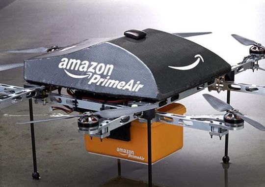
Amazon has announced plans to deliver packages to customers’ doorsteps using drones. Kochersberger, the Tech researcher, said he’s more convinced than ever that precision delivery could one day be more than a dream. His lab is creating a student competition to see who can design the best doorstep delivery drone.

But the days of drones replacing mail carriers are likely a decade or more away as the industry works to develop the technology to allow drones to sense and avoid obstacles and persuades the FAA it’s safe, said Jon Greene, associate director of the Mid-Atlantic Aviation Partnership.

And while package delivery may not be available soon, Greene said he expects the various uses of drones to continue expanding.

http://www.heraldcourier.com/news/local/drone-industry-expands-over-virginia/article_74e5090a-43b3-11e5-9bb8-87f01da09bac.html
 

Dealer’s drone shoots video to stand out


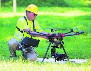
Dan Dorsey of the Jeff Wyler group says the drone can be flown by watching a monitor on the ground.

The Jeff Wyler Automotive Family near Cincinnati is going to new heights to wow vehicle buyers.

The 14-dealership group has purchased a drone — a remote-controlled, unmanned aircraft — to spice up promotions, social media campaigns and vehicle-delivery celebrations, said E-commerce Director Kevin Frye.

“In a highly competitive market, the need to differentiate yourself has never been more important,” Frye said.

This summer, Jeff Wyler Automotive paid $1,200 for the drone with a high-definition, GoPro camera mounted underneath the aircraft.

The camera is gyro-stabilized to minimize bouncing and disorientation while producing high-quality aerial photos and video, Frye said.

Frye, a former U.S. Navy aviator, said the drone is fun to fly. But Jeff Wyler Automotive has serious plans for it.

Perhaps the coolest use will be to provide customers taking delivery of vehicles with a memorable video. The camera will record salespeople handing over keys, hover shots of the driver through the passenger window and the car leaving the dealership.

That’s the kind of unique video that customers will want to post to their Facebook pages and other social networks, providing Jeff Wyler with indirect publicity, Frye said.

Frye envisions a multitude of other uses for the drone.

He said the Jeff Wyler Automotive video team has started experimenting with aerial shots of inventory lots to show shoppers the wide selection that each store offers.

The drone can safely fly up to 400 feet for the wide-angle shots needed to show inventory, he said.

Additionally, the video team has started shooting B-roll video and shots of dealership exteriors, logos and vehicles, Frye said.

Those will come in handy because the group sends vehicle videos and photos to shoppers whenever they inquire about a vehicle either electronically or by phone

Frye: Indirect publicity


Frye said the customary way of getting aerial dealership footage, hiring a helicopter, can easily cost $800 or more for one go-around. Just having that ability with the drone nearly pays for the cost of it, he said.

Other uses include shooting charitable and promotional events at the stores or highlighting Jeff Wyler’s contributions to the community. For example, the drone is being used to shoot the construction site of a new elementary school for the City of Milford, where Jeff Wyler headquarters are located. It also could record parades and fun runs.

Most of the videos and photos will be posted to store websites and social media channels, feeding those ever-hungry beasts for fresh content, Frye said.

The Jeff Wyler group ranks No. 39 on the Automotive News list of the top 150 dealership groups based in the U.S. with retail sales of 19,752 new vehicles in 2014.

Frye is no stranger to drones. In 1990, during the buildup to the Gulf War against Iraq, Frye flew on low-altitude missions that required military planes to be wary of early U.S. drones circling battlefields and waterways. That said, Frye and staff still have a learning curve on how best to fly and deploy the drone, he said.

The drone can be flown by watching a monitor on the ground, said Dan Dorsey, Jeff Wyler multimedia production manager. But the team has been using two-person teams with one watching the monitor to see what the camera is shooting and the other acting as a spotter to keep the drone from hitting trees and other obstacles, he said.

Frye said the group is in a trial stage, and there’s a chance the video produced eventually will lose the wow factor that makes it desirable today.

That’s a risk that the group is willing to take for a leg up on the competition.

“Sure, it could come and go,” Frye said. “But when you lead, you have to be willing to bleed.”


http://www.autonews.com/article/20150817/RETAIL/308179980/dealers-drone-shoots-video-to-stand-out


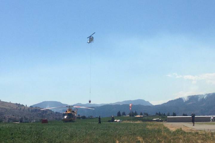
Drone shuts down air operations at Oliver fire scene

firehelis

BY BETHANY LINDSAY, VANCOUVER SUN

OLIVER, B.C. — The intrusion of a small drone into the airspace above an uncontained wildfire near Oliver grounded the entire fleet of aircraft working on the blaze for most of Sunday afternoon.

Eight helicopters and an air tanker team were all put out of action when the drone flew close to the Testalinden Creek fire at about 12:45 p.m. Sunday.

It took about five hours for crews got confirmation that it was safe to fly again.

“You can’t even imagine” how frustrating this is, fire information officer Noelle Kekula said during the delay.

“The fire is active and our No. 1 objective is to protect (homes). This is incredibly serious.”

Without “helicopters bucketing places,” members of the Oliver district fire department were forced to “climb the hillsides with hoses in their hands,” said deputy fire chief Bob Graham.

It meant “we had to go out and protect more of the area. The terrain is very steep and rocky and it’s difficult to access some of the spots.”

The RCMP worked to find the drone late Sunday afternoon, but had not found it or its operator.

The airspace over any active wildfire is automatically considered restricted, and Transport Canada regulations make it illegal to fly within five nautical miles to either side of the flames or less than 3,000 feet above it.

Violations can result in a fine of up to $1,000 for individuals or $5,000 for a corporation.

This marks the second time this year that an unmanned aircraft has interfered with crews fighting wildfires; a drone hovering around the Westside Road blaze near Kelowna earlier this summer shut down air operations there as well. The only other previous case of a drone flying too close to a wildfire in B.C. happened last summer in the Okanagan.

The most recent drone was a significant nuisance to firefighters in Oliver, who had yet to make any progress on containing the 15 square-kilometre fire. .

Incidents involving recreational drones interfering with planes and helicopters have been on the rise in recent years.

Earlier this month, a drone narrowly missed a seaplane as it landed on the Fraser River at Vancouver International Airport. The same week, a Cessna 172 flying over Stanley Park reported a drone buzzing around underneath it.

By August 6, 19 incidents involving drones had been reported to Transport Canada in 2015.

A recreational pilot operating a drone weighing under 35 kilograms doesn’t require either a licence or a special permit to fly but must follow a list of Transport Canada safety guidelines. Commercial operators, on the other hand, need a special flight operations certificate that includes restrictions on things like altitude and minimum distances from airports.

Some observers are calling for Transport Canada to crack down on recreational drone users.

“Public awareness and enforcement is lacking,” said Ernie Zeisman, president of a drone-training outfit in the B.C. Interior. “They need to begin clamping down.”

Transport Canada is holding consultations about possible regulations for recreational drone users. Some of the proposed amendments include minimum age requirements, knowledge tests, aircraft marking and registration, and pilot permits for some operators.

With files from The Canadian Press and Gordon Hoekstra and Joanne Lee-Young

Read more: http://www.vancouversun.com/news/Drone+shuts+down+operations+Oliver+fire+scene/11294451/story.html#ixzz3j3CCTVaK


Amazon chief Jeff Bezos hails UK drone rules

AmazonPrimeAir

Murad Ahmed, European Technology Correspondent

Amazon founder and chief executive Jeff Bezos has hailed the UK’s regulatory regime for drones, as the online retailer hints of the possibility of launching its flying delivery vehicles in Britain before initiating lift-off worldwide.

Mr Bezos said UK’s rules on unmanned aerial vehicles represented “a very encouraging example of good regulation”.

His endorsement comes amid growing hope that Britain can become an international hub for the non-military drone sector, a belief that stems from the fact that the UK’s regime on drones is more relaxed than elsewhere, particularly the US.

Britain’s Civil Aviation Authority has granted permission to more than 850 commercial groups to conduct aerial work in the country using the machines.

This regulatory regime has allowed US tech groups to set up test bases in the UK. Amazon began trials for its fleet of delivery drones in Cambridgeshire last year, having quickly gained the blessing of the UK authorities. But the Seattle-based company has had to wait months to gain similar permission to test its vehicles at home, with the US Federal Aviation Administration only granting approval last March.

 http://www.ft.com/intl/cms/s/0/d5869f38-4405-11e5-b3b2-1672f710807b.html#axzz3j3ANTCW4


Iowa State Extension field day to include information on drones

ISU researchers look over a drone.

An Iowa State University field day at the end of this month will feature a discussion on using Unmanned Aerial Vehicles on the farm. Ryan Bergman in the ISU’s Department of Ag and Biosystems Engineering is the organizer of the field day.

He says the UAV’s can be another tool used by growers. “There’s still a lot of unknowns in the area of UAV’s and aerial imagery specifically in the agriculture sector,” Bergman says. “And so a lot of what we are going to be showing at the field day, and a lot of the research that my team is doing here at Iowa State is focused around how do we utilize this imagery to help us make better management decisions for our operations and allow us to cost-effectively utilities this new tool.”

Bergman says the images from the drones can turn up many issues in the fields. “We can tell a lot of differences across the field, compaction issues show up relatively well in a lot of aerial images, drainage issues show up extremely well. Those are some of the early things that we are seeing, but we think there a lot of other uses that we can employ aerial imagery in down the road,” according toe Bergman.

While the drones are a new tool to get information on your crops, Bergman says its just one piece of the puzzle. “Whatever you are see in the imagery — at this point we aren’t recommending that you can make a management decision of that really — unless you can verify it on the ground what’s happening. It’s completely visual, so there can be a lot of times be other factors that are affecting that image and it may not be due to the crop,” Bergman says. He says growers will still have to do some leg work once they find potential issues in the images from a drone.

“That’s one thing that we’ve really been stressing — if you see something in the image that should tell you where in the field you should look — and then you go out there and look. And based on what you are seeing in the field based on the image, then you can make a decision off of that,” Bergman explains. An attorney with the Center for Agricultural Law and Taxation at Iowa State will also be on hand for a discussion on the legal issues surrounding UAV’s.

“That’s still kind of a gray area right now, and so that’s why we have her coming to kind of talk through some of those issues with the growers,” Bergman says. The field day is August 27th at the ISU research farm located near Boone on Highway 30. The field day starts at 8:30 and is free to the public.

http://www.radioiowa.com/2015/08/15/iowa-state-extension-field-day-to-include-information-on-drones/

How are environmentalists putting drones to use to help further their causes?

L_111914-research-droneDear EarthTalk: How are environmentalists putting drones to use to help further their causes?
– Joe Martin, Baltimore, MD

Conservationists are utilizing drone or “unmanned aerial systems” (UAS) technology to gather highly detailed imagery and other environmental data that is traditionally challenging to obtain. Wildlife biologist John Takekawa and his team at the U.S. Geological Survey’s Western Ecological Research Center (WERC), for example, are using drones to obtain aerial images of San Francisco Bay marshlands.

“It’s very hard to get some of the data sets in some of these areas that are remote or hard to reach in the marshes,” Takekawa explains. “If you have something that can fly over and get sensors that can report back to your computer, that’s what we’re looking for in exploring these types of technologies.”

Dr. Amy Woodget, a post-doctoral researcher at the University of Worcester in the UK, uses her small Draganflyer X6 UAS to collect high-resolution imagery of river channels. The images map the physical conditions within the rivers, including the channel topography, water depth and surface flow patterns, data all crucial for gauging river health and habitat conditions essential to the survival of local wildlife.

“The results obtained using UAS technologies provide unprecedented levels of detail concerning these physical river habitat parameters, with high levels of accuracy and precision,” Woodget says.

Drones are also helping preserve the Peruvian Amazon forest, where illegal gold mining and logging has cleared mahogany, Spanish cedar and other old-growth trees. Carlos Castaneda, coordinator of the Amazon Basin Conservation Association’s Los Amigos Conservation Concession, monitors the 550-square-mile Los Amigos reserve in southeastern Peru, home to a large diversity of plant and animal species, including palm swamps, bamboo thickets, giant otters, harpy eagles, spider monkeys and jaguars. Small drones weighing less than five pounds enable detection of any deforestation within the area.

Considering that more and more drones are being launched for conservation research, Linda Rothschild, an evolutionary biologist at NASA’s Ames Research Center, was concerned when she found out that UAVs sometimes get lost in coral reefs or other sensitive habitats. “As I started to hear about this, I thought, ‘Well, wouldn’t it be useful if the UAV was biodegradable, so if it crashed somewhere that was sensitive, it wouldn’t matter if it dissolved,’” Rothschild says.

So Rothschild created a biodegradable drone with a team of students in the 2014 International Genetically Engineered Machine (iGEM) competition. The team’s prototype took its first short flight in November 2014 at the iGEM competition in Boston. The drone, which resembles a cardboard cup holder, is made primarily of mycelium grown by New York-based Ecovative Design. The team grew cellulose leather-like sheets to coat the mycelium body and then covered the sheets with proteins sourced from the saliva of paper wasps—a water resistant material that the insects use to cover their nests. The biodegradable drone body is certainly a step forward, though the drone still uses a standard battery, motor and propellers.

Rothschild’s dream is to make a UAV where every part is made with something biodegradable, but for now, she says, “realistically, this is going to be much more of a hybrid vehicle.”


http://augustafreepress.com/how-are-environmentalists-putting-drones-to-use-to-help-further-their-causes/

Drone use shot down by Aspen Skiing Company over ski areas

aspenskijump

by Chad Abraham, Aspen Daily News

The Aspen Skiing Co. has informed the photographers with whom it contracts that they are not allowed to use aerial drones on the four ski mountains, clarifying what had been a gray area as popularity grows for the devices.

The policy, announced Thursday, also holds true for the public, and the regulation mirrors U.S. Forest Service rules on drones. The federal agency prohibits their use on public land unless a drone flier has obtained an exemption from the Federal Aviation Administration.

SkiCo decided to formalize its drone policy in writing and on its website because it is simply too dangerous, said spokesman Jeff Hanle.

“It’s way too risky to have those things flying around,” he said, noting the danger to people riding chairlifts and the proximity of Buttermilk to the Aspen-Pitkin County Airport. “Buttermilk is right there in the flight path.”

A man was cited for a misdemeanor in January for flying a drone near Buttermilk during the X Games. ESPN, which produces the extreme sports event, obtained permission from the FAA for the drones it used to film, Hanle said.

Others who have the FAA exemption for local drone use include producers of films and commercials. But as the technology has progressed and prices have dropped, drones mounted with cameras have exploded in popularity for people using them recreationally.

Matt Hobbs, owner of locally based Vital Films, has conducted multiple shoots on the ski areas. He’s also filmed public service announcements using a drone for, ironically, the Forest Service, he said.

Until the Forest Service established its zero-tolerance policy on the devices, film- and commercial-makers were in “uncharted territory,” Hobbs said. “The biggest thing, from my understanding, is that airspace [away from airports] can’t be controlled, just where you take off and land from.

“Everything’s just so gray now, which is why we chose to back off for now.”

He said his company now only flies drones on private property.

Hobbs provided a Forest Service memo issued in March that cites the FAA’s position on drones: “Operators who wish to fly an unmanned aircraft for civil use must obtain an FAA airworthiness certificate. Certificates are issued with accompanying operational limitations that are appropriate to the applicant’s operation.”

The Colorado Passenger Tramway Safety Board, which has oversight over ski lifts, mandates that helicopters used in commercial filming stay a certain distance away from ski lifts, Hanle said, adding he assumed the same regulation would cover drones. Efforts to reach a representative of the tramway board were unsuccessful.

SkiCo has used drones in its own commercial efforts, and “we’ll now make sure we’re permitted and check with the FAA,” Hanle said.


http://www.aspendailynews.com/section/home/167850

Amazon’s (Not-so) Secret Drone Test Site

by: Gary Mortimer • 16 August 2015

A rumour and purple tent was all it took for GeekWire’s Jacob Dement to claim a secret Amazon drone testing site.

There I was, air conditioner blasting in my Car2Go as I sat in front of a red gate on a gravel road in rural Snoqualmie, Wash. Multiple locals told me this was what I had come looking for: the entrance to Amazon’s secret drone testing site.

I wasn’t lucky enough to show up on a day when Amazon’s prototype delivery drone was being tested. But then I pulled up Google Maps to try to get a sense of where exactly I was.

And that’s when I saw it.

This satellite image, taken on a previous day, shows activity in the area beyond the gate. You can see a couple dark objects on the ground at either end of the image, what looks like a purple tent, a white van and some other vehicles — exactly where people in the area told me they’ve seen Amazon’s team set up.

Does it really matter if some Amazon employees are off multirotor flying somewhere?

We know they are!

Lets find some facts for Jacob, all thanks to published data from the FAA.

Long time sUAS News readers will be aware of our Drone Spotters collection of drone tail numbers from around the world, set up to monitor who was selling what to where. I notice Amazon registered its third official drone. N394PA appeared on the register just last Thursday.

We can learn some stuff from their naming, its a mark 24, so I think it’s fair to assume the 24th type of prototype and its serial number 14 so there are at least 14 mark 24’s out in the wild.

It joins N391PA and N392PA, serial numbers 6 and 8 respectively.

N393PA is not going to happen as it’s already allocated to an autogyro.

The questions I would ask is have they distributed other airframes to test simultaneously around the world and are Amazon just creating marketing footage in the USA?

Flying around a bit at the end of a track is hardly testing detect sense and avoid. Its not probing the platforms sensitivity to EMF. Its not testing a whole host of things.

Jacob, please do me a favour pop back and see if you can find a second site. One about 5km away. One that Amazon might be flying test deliveries to. That would be the sort of thing I would be testing to a track in the middle of nowhere.

Jacob also head off to Walmart and buy a scanner Unidenscanner

Then listen out on the local air traffic frequencies just in case the Amazon guys are doing the right thing and calling their position for VFR traffic in the local area.

It might also be worth dropping into Fall City Airport and finding out if any Amazon execs have flown in. They probably have a working relationship with the test team.

I would do it myself but its Sunday morning in South Africa and time to go out for a family breakfast. (some time passes) After breakfast I found the spot, skip to the bottom.

Here’s what Amazons Paul Misener, Vice President, Global Public Policy had to say last year in their FAA 333 exemption.

Our R&D operations will provide for a level of safety that far exceeds the level of safety required by FAA for hobbyists and manufacturers of model aircraft. The following operating procedures will apply during the R&D testing conducted under this exemption request:

  1. The sUAS will (i) have a maximum weight of less than 55 pounds; (ii) be rotor‐ powered via a battery source; and (iii) be U.S.‐registered and display marks in accordance with 14 C.F.R. Part 45, Subpart C.5
  2. Our sUAS R&D testing under this exemption will be conducted (i) within the visual line of sight of the operator and/or one or more observers; (ii) at less than 400 feet AGL; and (iii) within Class G airspace.
  3. The operations will be conducted in a confined area over isolated Amazon private property located a sufficient distance away from (i) any airport, heliport, seaplane base, spaceport or other location with aviation activities; (ii) any densely populated areas; and (iii) any military or U.S. government installations or airfields.6
  4. All operations will remain within the lateral and vertical boundaries of the operating area, taking into account all factors, including wind, gross weight and glide distances, that may affect the capability of the sUAS to remain within the airspace boundary; moreover, the integrity of the operating area will be reinforced by geo‐fencing,7 including the ceiling height of no more than 400 feet AGL.
  5. Our sUAS R&D testing under this exemption will be conducted (i) under the supervision of a designated pilot in command (PIC) who has final responsibility for the operation in accordance with 14 C.F.R. § 91.3 and either (A) holds a current FAA private pilot certificate issued under 14 C.F.R. Part 61, Subpart E, a higher FAA pilot certification, or a FAA‐recognized equivalent8 or (B) has completed FAA private pilot ground instruction and passed the FAA private pilot written examination or FAA‐recognized equivalent; and (ii) using only operators that have completed training on the normal, abnormal, and emergency procedures in specific details and demonstrated proficiency with the sUAS being operated.
  6. No operator or observer will engage in, nor may an operator or observer permit, any activity during a critical phase of flight which could distract any operator or observer from the performance of his/her duties or interfere in any way with the proper conduct of his/her duties.
  7. Operators will maintain the sUAS system in a condition for safe operation, and conduct a pre‐flight inspection prior to each flight so as to ensure that the sUAS, control station, data link equipment, payload, and support equipment are in a condition for safe operation and in a configuration appropriate for the purpose of the intended flight.
  8. The operators and observers will maintain two‐way communications with each other during all operations; if unable to maintain two‐way communications, or if any condition occurs that may otherwise cause the operation to be unsafe, the operator will immediately conclude the operation.
  9. Each sUAS will safely stop operating and return automatically to a specific location on Amazon’s private property if the communications link is lost.
  10. For each sUAS, the observer will have the ability to press a physical button, that will be within his/her reach at all times, that reduces power to the vehicle so as to force a controlled landing; both the hardware and communication for this safety system will be physically separate from the sUAS flight control systems.
  11. Testing operations will be conducted on private property, and only Amazon employees, contract personnel, and invitees will be invited to the operations area; security measures will be put in place to deter unauthorized access.

A gentle VR flight and I found where it is

amazonssecretsite

amazonssecretsite2

I guess distance is a relative, living as I do in Africa 45 minutes very often is the minimum you have to travel for more life. I have lived in places where an aeroplane was the only way to the shops.

With that in mind, this line…

So I grabbed a Car2Go in Seattle and made the 45 minute drive out into the middle of nowhere. It’s the kind of place where “No Trespassing” signs outnumber doorbells and people don’t seem fond of strangers wandering on to their front porches.

Then checking, its 6 minutes to the nearest African sounding joint, Sahara Pizza (tenuous I know) Raised a smile here. Also amusing the railway stations of startup and goldbar to the right of the title map. That’s why I made it so wide.


http://www.suasnews.com/2015/08/37836/amazons-secret-drone-test-site/

North American drone meet takes place in Stephentown

stevensonfpv

By: Asa Stackel

In Stephentown around noontime Friday, they weren’t the drones you’re used to.  Flying in a park field of NY-22 were fixed wing FPVs or First Person View drones. With the goggles, it’s like you’re actually on the aircraft.

“We fly it FPV, through this little camera here. The video transmits through this little antenna here,” said Josh Noone, drone pilot.

Josh, along with almost a hundred pilots from across North America are in Stephentown flying all kinds of FPV drones. Most build those foam “spec wings” themselves and most do it just for fun.  But that doesn’t mean they aren’t concerned with the controversy surrounding drones.

“Drones get a bad rep, unfortunately, I think there’s a lot of paranoia with the cameras that are attached,” said Thomas McCullough, NEFVP.

Adam Sloan of Birds Eye View Aerobotics sells a drone that can lift vertically like a helicopter and fly forward like a plane. Hobbyists use it, but it’s used in mapping, power line inspection, and agriculture.

“I just think the FAA has been dragging their feet on this technology for over ten years,” said Sloan.

Right now, each person interested in flying to make money has to get specific permission from the Federal Aviation Administration to fly. Sloan wants the FAA to relax the rules.

“I would like to see some common sense guidelines. We never have any need to go above 400 feet, manned aircraft have no need to come below 500 feet. There’s already natural stratification there,” said Sloan.

Unlike Adam, Most drone pilots are in Stephentown for fun.

“When they rip through the finish line, it’s like wah, wah, wah. It sounds awesome,” said Noone.

They just everyone to know how fun it is.


http://wnyt.com/article/stories/s3879747.shtml


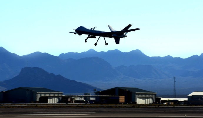
RPAs prove vital in fight against ISIL

isilrepsm

By Tech. Sgt. Nadine Barclay, 432nd Wing/432nd Air Expeditionary Wing

CREECH AIR FORCE BASE, Nev. (AFNS) – From August 2014 to August 2015, the 432nd Wing has directly supported Operation Inherent Resolve, a U.S. Central Command and partner nation’s campaign to conduct targeted airstrikes in Iraq and Syria as part of the comprehensive strategy to degrade and defeat the Islamic State of Iraq and the Levant.

“OIR has highlighted the strengths of (remotely piloted aircraft) operations, namely a single-weapon system that can (find, fix, track, target, engage, and assess) with flexibility, endurance and precision,” said Lt. Col. Erik, the 15th Reconnaissance Squadron commander. “In addition, we have the communications necessary to reach back to multiple supporting agencies, and disseminate our (intelligence, surveillance and reconnaissance) feed real-time to multiple end users. This builds situational awareness of the (area of responsibility), which is especially important due to the dynamic nature of OIR combat operations.”

While the RPA mission in Iraq and Syria initially focused on information gathering and battlespace awareness, the 432nd WG’s involvement quickly escalated as the demand for ISR grew to accurately capture real-time operations.

“Things progressed very quickly, we were playing a reactive part, now we are much more established and proactive,” said Senior Airman Jeffery, a MQ-1B Predator intelligence instructor. “The nature of the mission is much more clear and precise then it was at the beginning which has allowed us to be as effective as possible.”

In OIR, the 432nd WG/432nd Air Expeditionary Wing has contributed approximately 4,300 sorties, employed 1,000 weapons and conducted 400 ‘buddy lase.’ A buddy lase is when aircrew from one aircraft uses a combat laser to guide weapons released another aircraft to a target. A majority of the sorties and strikes were performed by the 432nd WG. The strikes are an experience Capt. Ryan, a 15th RS Predator pilot, knows all too well.

“I had the first RPA strike of OIR,” Ryan recalled. “It was exciting to know what the threat was and to protect the guys on the ground was exhilarating. I felt like I was able to directly contribute.”

Although many sorties were flown by RPAs, joint efforts capitalized on the capabilities of the joint warfighter thus integrating manned and unmanned assets to assist friendly ground forces.

“This has been one of the biggest improvements to RPA operations in recent years,” Erik said. “One of the strengths of RPA cockpits is the ability to use multiple means of communication (computer, phone and airborne radio) to integrate with other assets. The challenge facing our crews is how to leverage the strengths and weaknesses of these various communication means, and we have made great strides in OIR to optimize this.”

As part of this integration process, manned aircraft like the Navy F-18 Hornets use RPAs to buddy lase targets.

To some, changing the misconceptions associated with this revolutionary aircraft is sometimes a mission in itself, but illustrating the platforms capability in combat is setting the stage to clear up misunderstandings associated with RPAs.

“Before OIR many people may not have known what an RPA was truly capable of,” Ryan said. “Now before combatant commanders take the risk of potentially losing a manned aircraft they will come to us and ask if we’ve found them targets. We have 24/7 coverage, so we know what the battlefield looks like and how it has changed. They’re using us for their situational awareness which improves their safety as well.”

A unique aspect of the RPA enterprise is that these aircrew members will see sustained direct combat support very early in their Air Force careers, which is less common in other aircraft platforms.

“From the very beginning, I’ve felt I’ve had impact in the mission that we are doing,” Jeffrey said. “I don’t feel I would have had this experience and impact had I been in another career field. It’s a great thing to be in the RPA enterprise as a brand new Airman starting out.”

In the RPA career field today, the average age of Airmen flying combat missions is 18-24 years old, something rarely seen in traditionally manned aircraft career fields.

“I can’t be more proud of our crews and the professional airmanship they exhibit on a daily basis,” Erik said. “Due to the growth of the RPA community, we have a large percentage of relatively young crew members. Based on the nature of our combat operations, they build experience at a much faster rate than the norm. Their pride, motivation and discipline are unquestionable and directly lead to our success in combat operations.”

As OIR passed the one year mark on Aug. 8, Ryan said morale is high and the men and women of his unit are the most professional people he has had the pleasure of working with.

“Every day they surprise me with how they act and react to the changing environment of war,” Ryan said. “I am extremely proud of what I do. Our motto is P2P, which is short for perform to prevent. The meaning behind it is that we perform at our best to keep Soldiers from deploying into harm’s way. It pushes us to do our jobs, which is to save American lives.”

According to Defense Department as of Aug. 7, 2015, airstrikes have been responsible for damaging or destroying more than 10,684 targets that further deny the enemy the capability to inflict damage to America or its allies.

“It’s an honor to know that we are able to lead the way, and rapidly execute missions in a new AOR based on orders from our national leadership,” Erik said. “It’s also true that this is an honor shared by the entire RPA community. Collectively, we present unique and effective airpower options for our combatant commanders to achieve their objectives.”